Chenoise geodata
Chenoise (Île-de-France) is a populated place; located in France in Europe/Paris (GMT+2) time zone. With population of 1,240 people, there are 7330 cities with bigger population in this country. Compared to other cities in France, 71.2% of cities are located further ↓South; 60.5% of cities are located further ←West and 53.9% of cities have lower elevation than Chenoise. Note1
Administrative division(s):
- Level 1: Île-de-France
- Level 2: Seine-et-Marne
- Level 3: Arrondissement de Provins
- Level 4: Chenoise-Cucharmoy


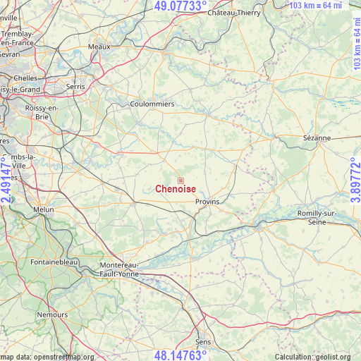
Chenoise GPS coordinates[2]
48° 36' 52.632" North, 3° 11' 40.524" East
| Map corner | latitude | longitude |
|---|---|---|
| Upper-left | 49.07733°, | 2.49147° |
| Center: | 48.61462°, | 3.19459° |
| Lower-right: | 48.14763°, | 3.89772° |
| Map W x H: | 103.4×103.4 km | = 64.2×64.2mi |
| max Lat: | 51.07786° ⇑28.8% North |
| Chenoise: | 48.61462° |
| min Lat: | ⇓71.2% South 41.3874° |
| min Long | Chenoise | max Long |
| -5.08615° | 3.19459° | 9.52242° |
| W 60.5%⇐ | ⇒39.5% E |
Elevation
Elevation of Chenoise is 146 m = 479 ft, and this is 47.7 m = 156 ft below average elevation for this country.
| Max E: |
2333 m = 7654 ft | 46.1% |
| Avg. | 193.7 m = 635 ft | |
| Chenoise | 146 m = 479 ft | |
Min E: |
-1 m = -3 ft | 53.9% |
See also: France elevation on elevation.city.
Geographical zone
Chenoise is located in North temperate zone (between Tropic of Cancer and the Arctic Circle). Distance of this North polar circle is 1995.7 km =1240.1 mi to North.| Distance of | km | miles | from Chenoise |
|---|---|---|---|
| North Pole | 4601.6 | 2859.3 | to North |
| Arctic Circle | 1995.7 | 1240.1 | to North |
| Tropic Cancer | 2799.5 | 1739.5 | to South |
| Equator | 5405.4 | 3358.8 | to South |


Nearby cities:
15 places around Chenoise: (largest is in red/bold)
• Bannost-Villegagnon
7.1 km =4.4 mi,  358°
358°
• Beton-Bazoches
10.3 km =6.4 mi,  21°
21°
• Chalautre-la-Petite
12.8 km =8 mi,  137°
137°
• Gastins
12.9 km =8 mi,  277°
277°
• Jouy-le-Châtel
7.5 km =4.7 mi,  320°
320°
• La Croix-en-Brie
9 km =5.6 mi,  255°
255°
• Longueville
11.7 km =7.3 mi,  160°
160°
• Provins
9.9 km =6.2 mi,  128°
128°
• Pécy
9.4 km =5.8 mi,  298°
298°
• Rampillon
11.8 km =7.3 mi,  232°
232°
• Saint-Brice
10.9 km =6.8 mi,  118°
118°
• Saint-Loup-de-Naud
9 km =5.6 mi,  177°
177°
• Sainte-Colombe
10.4 km =6.5 mi,  154°
154°
• Savins
11.8 km =7.3 mi, 177°
• Vaudoy-en-Brie
11.8 km =7.3 mi,  314°
314°
Sources, notices
• [Note1] Compared only with cities in France existing in our database
• [Src1] Map data: © OpenStreetMap contributors (CC-BY-SA)
• [Src2] Other city data from geonames.org with taken over terms of usage.
• [Src3] Geographical zone / Annual Mean Temperature by Robert A. Rohde @ Wikipedia
