Nomexy geodata
Nomexy (Grand Est) is a populated place; located in France in Europe/Paris (GMT+2) time zone. With population of 2,310 people, there are 4176 cities with bigger population in this country. Compared to other cities in France, 64.7% of cities are located further ↓South; 91% of cities are located further ←West and 79.4% of cities have lower elevation than Nomexy. Note1
Administrative division(s):
- Level 1: Grand Est
- Level 2: Vosges
- Level 3: Arrondissement d’Épinal
- Level 4: Nomexy


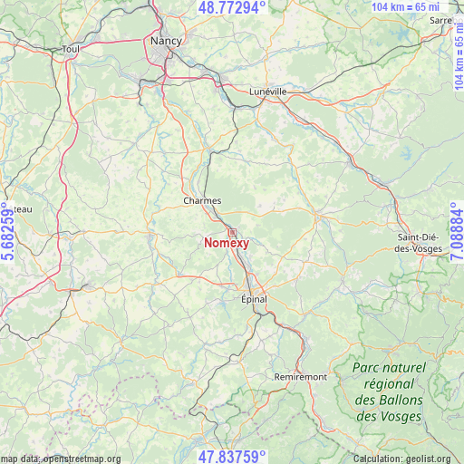
Nomexy GPS coordinates[2]
48° 18' 26.676" North, 6° 23' 8.592" East
| Map corner | latitude | longitude |
|---|---|---|
| Upper-left | 48.77294°, | 5.68259° |
| Center: | 48.30741°, | 6.38572° |
| Lower-right: | 47.83759°, | 7.08884° |
| Map W x H: | 104×104 km | = 64.6×64.6mi |
| max Lat: | 51.07786° ⇑35.3% North |
| Nomexy: | 48.30741° |
| min Lat: | ⇓64.7% South 41.3874° |
| min Long | Nomexy | max Long |
| -5.08615° | 6.38572° | 9.52242° |
| W 91%⇐ | ⇒9% E |
Elevation
Elevation of Nomexy is 284 m = 932 ft, and this is 90.3 m = 296 ft above average elevation for this country.
| Max E: |
2333 m = 7654 ft | 20.6% |
| Nomexy | 284 m 932 ft | |
| Avg. | 193.7 m = 635 ft | |
Min E: |
-1 m = -3 ft | 79.4% |
See also: France elevation on elevation.city.
Geographical zone
Nomexy is located in North temperate zone (between Tropic of Cancer and the Arctic Circle). Distance of this North polar circle is 2029.9 km =1261.3 mi to North.| Distance of | km | miles | from Nomexy |
|---|---|---|---|
| North Pole | 4635.8 | 2880.6 | to North |
| Arctic Circle | 2029.9 | 1261.3 | to North |
| Tropic Cancer | 2765.4 | 1718.3 | to South |
| Equator | 5371.3 | 3337.6 | to South |


Nearby cities:
15 places around Nomexy: (largest is in red/bold)
• Charmes
10 km =6.2 mi,  315°
315°
• Chavelot
9 km =5.6 mi,  154°
154°
• Châtel-sur-Moselle
1 km =0.6 mi,  38°
38°
• Darnieulles
12.3 km =7.6 mi,  192°
192°
• Dogneville
10.9 km =6.8 mi, 149°
• Essegney
8.4 km =5.2 mi, 322°
• Girmont
6.7 km =4.2 mi,  143°
143°
• Golbey
12.8 km =8 mi,  161°
161°
• Igney
3.8 km =2.4 mi,  167°
167°
• Jeuxey
14 km =8.7 mi, 147°
• Les Forges
14.4 km =8.9 mi,  179°
179°
• Portieux
5.1 km =3.2 mi, 323°
• Thaon-les-Vosges
6.8 km =4.2 mi, 160°
• Uxegney
12.4 km =7.7 mi, 185°
• Vincey
5.2 km =3.2 mi,  309°
309°
Sources, notices
• [Note1] Compared only with cities in France existing in our database
• [Src1] Map data: © OpenStreetMap contributors (CC-BY-SA)
• [Src2] Other city data from geonames.org with taken over terms of usage.
• [Src3] Geographical zone / Annual Mean Temperature by Robert A. Rohde @ Wikipedia
