Chavanay geodata
Chavanay (Auvergne-Rhône-Alpes) is a populated place; located in France in Europe/Paris (GMT+2) time zone. With population of 2,330 people, there are 4141 cities with bigger population in this country. Compared to other cities in France, 75.1% of cities are located further ↑North; 74.1% of cities are located further ←West and 54.2% of cities have lower elevation than Chavanay. Note1
Administrative division(s):
- Level 1: Auvergne-Rhône-Alpes
- Level 2: Département de la Loire
- Level 3: Arrondissement de Saint-Étienne
- Level 4: Chavanay


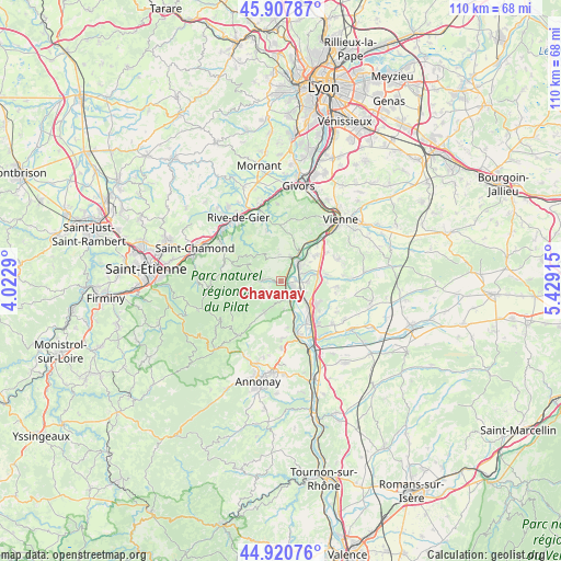
Chavanay GPS coordinates[2]
45° 24' 59.292" North, 4° 43' 33.672" East
| Map corner | latitude | longitude |
|---|---|---|
| Upper-left | 45.90787°, | 4.0229° |
| Center: | 45.41647°, | 4.72602° |
| Lower-right: | 44.92076°, | 5.42915° |
| Map W x H: | 109.8×109.8 km | = 68.2×68.2mi |
| max Lat: | 51.07786° ⇑75.1% North |
| Chavanay: | 45.41647° |
| min Lat: | ⇓24.9% South 41.3874° |
| min Long | Chavanay | max Long |
| -5.08615° | 4.72602° | 9.52242° |
| W 74.1%⇐ | ⇒25.9% E |
Elevation
Elevation of Chavanay is 147 m = 482 ft, and this is 46.7 m = 153 ft below average elevation for this country.
| Max E: |
2333 m = 7654 ft | 45.8% |
| Avg. | 193.7 m = 635 ft | |
| Chavanay | 147 m = 482 ft | |
Min E: |
-1 m = -3 ft | 54.2% |
See also: France elevation on elevation.city.
Geographical zone
Chavanay is located in North temperate zone (between Tropic of Cancer and the Arctic Circle). Distance of this North polar circle is 2351.3 km =1461 mi to North.| Distance of | km | miles | from Chavanay |
|---|---|---|---|
| North Pole | 4957.2 | 3080.3 | to North |
| Arctic Circle | 2351.3 | 1461 | to North |
| Tropic Cancer | 2443.9 | 1518.6 | to South |
| Equator | 5049.8 | 3137.8 | to South |


Nearby cities:
15 places around Chavanay: (largest is in red/bold)
• Auberives-sur-Varèze
7.3 km =4.5 mi,  86°
86°
• Chuyer
5.2 km =3.2 mi,  330°
330°
• Clonas-sur-Varèze
5.1 km =3.2 mi, 93°
• Condrieu
6.1 km =3.8 mi,  32°
32°
• Les Roches-de-Condrieu
5.2 km =3.2 mi,  38°
38°
• Maclas
6.9 km =4.3 mi,  209°
209°
• Pélussin
3.3 km =2.1 mi,  275°
275°
• Roisey
5 km =3.1 mi,  231°
231°
• Saint-Alban-du-Rhône
2.6 km =1.6 mi,  77°
77°
• Saint-Clair-du-Rhône
4.5 km =2.8 mi,  51°
51°
• Saint-Michel-sur-Rhône
2.9 km =1.8 mi,  22°
22°
• Saint-Pierre-de-Bœuf
5.8 km =3.6 mi,  161°
161°
• Saint-Prim
5.8 km =3.6 mi, 51°
• Véranne
7.2 km =4.5 mi,  223°
223°
• Vérin
4.7 km =2.9 mi, 27°
Sources, notices
• [Note1] Compared only with cities in France existing in our database
• [Src1] Map data: © OpenStreetMap contributors (CC-BY-SA)
• [Src2] Other city data from geonames.org with taken over terms of usage.
• [Src3] Geographical zone / Annual Mean Temperature by Robert A. Rohde @ Wikipedia
