Saint-Alban-du-Rhône geodata
Saint-Alban-du-Rhône (Auvergne-Rhône-Alpes) is a populated place; located in France in Europe/Paris (GMT+2) time zone. With population of 903 people, there are 9626 cities with bigger population in this country. Compared to other cities in France, 75% of cities are located further ↑North; 74.4% of cities are located further ←West and 59.1% of cities have lower elevation than Saint-Alban-du-Rhône. Note1
Administrative division(s):
- Level 1: Auvergne-Rhône-Alpes
- Level 2: Département de l'Isère
- Level 3: Arrondissement de Vienne
- Level 4: Saint-Alban-du-Rhône


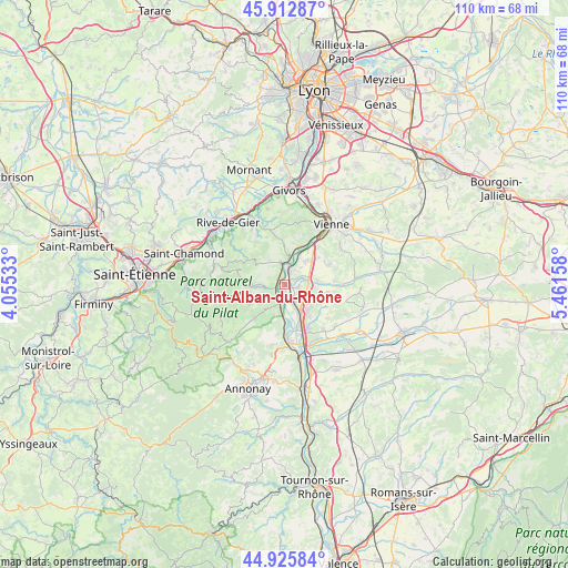
Saint-Alban-du-Rhône GPS coordinates[2]
45° 25' 17.436" North, 4° 45' 30.42" East
| Map corner | latitude | longitude |
|---|---|---|
| Upper-left | 45.91287°, | 4.05533° |
| Center: | 45.42151°, | 4.75845° |
| Lower-right: | 44.92584°, | 5.46158° |
| Map W x H: | 109.7×109.7 km | = 68.2×68.2mi |
| max Lat: | 51.07786° ⇑75% North |
| Saint-Alban-du-Rhône: | 45.42151° |
| min Lat: | ⇓25% South 41.3874° |
| min Long | Saint-Alban-du- | max Long |
| -5.08615° | 4.75845° | 9.52242° |
| W 74.4%⇐ | ⇒25.6% E |
Elevation
Elevation of Saint-Alban-du-Rhône is 166 m = 545 ft, and this is 27.7 m = 91 ft below average elevation for this country.
| Max E: |
2333 m = 7654 ft | 40.9% |
| Avg. | 193.7 m = 635 ft | |
| Saint-Alban-du-Rhône | 166 m = 545 ft | |
Min E: |
-1 m = -3 ft | 59.1% |
See also: France elevation on elevation.city.
Geographical zone
Saint-Alban-du-Rhône is located in North temperate zone (between Tropic of Cancer and the Arctic Circle). Distance of this North polar circle is 2350.8 km =1460.7 mi to North.| Distance of | km | miles | from Saint-Alban-du-Rhône |
|---|---|---|---|
| North Pole | 4956.7 | 3079.9 | to North |
| Arctic Circle | 2350.8 | 1460.7 | to North |
| Tropic Cancer | 2444.5 | 1518.9 | to South |
| Equator | 5050.4 | 3138.2 | to South |


Nearby cities:
15 places around Saint-Alban-du-Rhône: (largest is in red/bold)
• Auberives-sur-Varèze
4.7 km =2.9 mi,  90°
90°
• Chavanay
2.6 km =1.6 mi,  257°
257°
• Cheyssieu
6.3 km =3.9 mi,  83°
83°
• Chuyer
6.4 km =4 mi,  308°
308°
• Clonas-sur-Varèze
2.7 km =1.7 mi,  108°
108°
• Condrieu
4.7 km =2.9 mi,  8°
8°
• Le Péage-de-Roussillon
6.1 km =3.8 mi,  150°
150°
• Les Roches-de-Condrieu
3.5 km =2.2 mi, 11°
• Pélussin
5.8 km =3.6 mi,  267°
267°
• Roussillon
6.9 km =4.3 mi,  140°
140°
• Saint-Clair-du-Rhône
2.5 km =1.6 mi,  23°
23°
• Saint-Michel-sur-Rhône
2.5 km =1.6 mi,  325°
325°
• Saint-Pierre-de-Bœuf
6.1 km =3.8 mi,  186°
186°
• Saint-Prim
3.7 km =2.3 mi,  33°
33°
• Vérin
3.6 km =2.2 mi,  353°
353°
Sources, notices
• [Note1] Compared only with cities in France existing in our database
• [Src1] Map data: © OpenStreetMap contributors (CC-BY-SA)
• [Src2] Other city data from geonames.org with taken over terms of usage.
• [Src3] Geographical zone / Annual Mean Temperature by Robert A. Rohde @ Wikipedia
