Chavagnes-en-Paillers geodata
Chavagnes-en-Paillers (Pays de la Loire) is a populated place; located in France in Europe/Paris (GMT+2) time zone. With population of 3,168 people, there are 3074 cities with bigger population in this country. Compared to other cities in France, 56.3% of cities are located further ↑North; 90.4% of cities are located further →East and 75.8% of cities have higher elevation than Chavagnes-en-Paillers. Note1
Administrative division(s):
- Level 1: Pays de la Loire
- Level 2: Département de la Vendée
- Level 3: Arrondissement de La Roche-sur-Yon
- Level 4: Chavagnes-en-Paillers
Current local time in Chavagnes-en-Paillers:
12:43 PM, SaturdayDifference from your time zone: hours


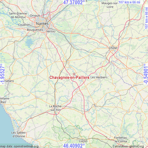
Chavagnes-en-Paillers GPS coordinates[2]
46° 53' 30.012" North, 1° 15' 7.704" West
| Map corner | latitude | longitude |
|---|---|---|
| Upper-left | 47.37002°, | -1.95527° |
| Center: | 46.89167°, | -1.25214° |
| Lower-right: | 46.40902°, | -0.54901° |
| Map W x H: | 106.9×106.9 km | = 66.4×66.4mi |
| max Lat: | 51.07786° ⇑56.3% North |
| Chavagnes-en-Paillers: | 46.89167° |
| min Lat: | ⇓43.7% South 41.3874° |
| min Long | Chavagnes-en-Pa | max Long |
| -5.08615° | -1.25214° | 9.52242° |
| W 9.6%⇐ | ⇒90.4% E |
Elevation
Elevation of Chavagnes-en-Paillers is 65 m = 213 ft, and this is 128.7 m = 422 ft below average elevation for this country.
| Max E: |
2333 m = 7654 ft | 75.8% |
| Avg. | 193.7 m = 635 ft | |
| Chavagnes-en-Paillers | 65 m = 213 ft | |
Min E: |
-1 m = -3 ft | 24.2% |
See also: France elevation on elevation.city.
Geographical zone
Chavagnes-en-Paillers is located in North temperate zone (between Tropic of Cancer and the Arctic Circle). Distance of this North polar circle is 2187.3 km =1359.1 mi to North.| Distance of | km | miles | from Chavagnes-en-Paillers |
|---|---|---|---|
| North Pole | 4793.2 | 2978.4 | to North |
| Arctic Circle | 2187.3 | 1359.1 | to North |
| Tropic Cancer | 2607.9 | 1620.5 | to South |
| Equator | 5213.9 | 3239.8 | to South |


Nearby cities:
15 places around Chavagnes-en-Paillers: (largest is in red/bold)
• Bazoges-en-Paillers
9 km =5.6 mi,  78°
78°
• Boufféré
10.2 km =6.3 mi,  319°
319°
• Boulogne
12.1 km =7.5 mi,  205°
205°
• Chauché
7.1 km =4.4 mi,  192°
192°
• La Boissière-de-Montaigu
8 km =5 mi,  35°
35°
• La Copechagnière
8.6 km =5.3 mi,  236°
236°
• La Guyonnière
8.1 km =5 mi,  0°
0°
• La Rabatelière
3.4 km =2.1 mi, 191°
• Les Brouzils
5.3 km =3.3 mi,  262°
262°
• Mesnard-la-Barotière
12.2 km =7.6 mi,  107°
107°
• Montaigu
10.4 km =6.5 mi,  335°
335°
• Saint-Denis-la-Chevasse
11.1 km =6.9 mi,  226°
226°
• Saint-Fulgent
7.1 km =4.4 mi,  127°
127°
• Saint-Georges-de-Montaigu
6.8 km =4.2 mi,  333°
333°
• Treize-Septiers
10.5 km =6.5 mi,  9°
9°
Sources, notices
• [Note1] Compared only with cities in France existing in our database
• [Src1] Map data: © OpenStreetMap contributors (CC-BY-SA)
• [Src2] Other city data from geonames.org with taken over terms of usage.
• [Src3] Geographical zone / Annual Mean Temperature by Robert A. Rohde @ Wikipedia
