La Boissière-de-Montaigu geodata
La Boissière-de-Montaigu (Pays de la Loire) is a populated place; located in France in Europe/Paris (GMT+2) time zone. With population of 1,683 people, there are 5565 cities with bigger population in this country. Compared to other cities in France, 55.8% of cities are located further ↑North; 89.9% of cities are located further →East and 69.2% of cities have higher elevation than La Boissière-de-Montaigu. Note1
Administrative division(s):
- Level 1: Pays de la Loire
- Level 2: Département de la Vendée
- Level 3: Arrondissement de La Roche-sur-Yon
- Level 4: La Boissière-de-Montaigu
Current local time in La Boissière-de-Montaigu:
11:25 AM, SaturdayDifference from your time zone: hours


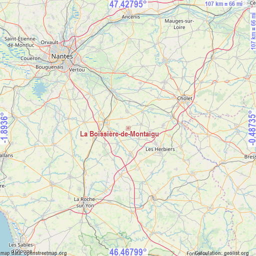
La Boissière-de-Montaigu GPS coordinates[2]
46° 57' 0.432" North, 1° 11' 25.692" West
| Map corner | latitude | longitude |
|---|---|---|
| Upper-left | 47.42795°, | -1.8936° |
| Center: | 46.95012°, | -1.19047° |
| Lower-right: | 46.46799°, | -0.48735° |
| Map W x H: | 106.7×106.7 km | = 66.3×66.3mi |
| max Lat: | 51.07786° ⇑55.8% North |
| La Boissière-de-Montaigu: | 46.95012° |
| min Lat: | ⇓44.2% South 41.3874° |
| min Long | La Boissière-d | max Long |
| -5.08615° | -1.19047° | 9.52242° |
| W 10.1%⇐ | ⇒89.9% E |
Elevation
Elevation of La Boissière-de-Montaigu is 80 m = 262 ft, and this is 113.7 m = 373 ft below average elevation for this country.
| Max E: |
2333 m = 7654 ft | 69.2% |
| Avg. | 193.7 m = 635 ft | |
| La Boissière-de-Montaigu | 80 m = 262 ft | |
Min E: |
-1 m = -3 ft | 30.8% |
See also: France elevation on elevation.city.
Geographical zone
La Boissière-de-Montaigu is located in North temperate zone (between Tropic of Cancer and the Arctic Circle). Distance of this North polar circle is 2180.8 km =1355.1 mi to North.| Distance of | km | miles | from La Boissière-de-Montaigu |
|---|---|---|---|
| North Pole | 4786.7 | 2974.3 | to North |
| Arctic Circle | 2180.8 | 1355.1 | to North |
| Tropic Cancer | 2614.4 | 1624.5 | to South |
| Equator | 5220.4 | 3243.8 | to South |


Nearby cities:
15 places around La Boissière-de-Montaigu: (largest is in red/bold)
• Bazoges-en-Paillers
6.3 km =3.9 mi,  138°
138°
• Beaurepaire
8.9 km =5.5 mi,  120°
120°
• Boussay
10.5 km =6.5 mi,  2°
2°
• Chavagnes-en-Paillers
8 km =5 mi,  215°
215°
• La Bruffière
7.2 km =4.5 mi,  355°
355°
• La Gaubretière
9.8 km =6.1 mi,  95°
95°
• La Guyonnière
4.8 km =3 mi,  289°
289°
• Les Landes-Genusson
5.9 km =3.7 mi,  71°
71°
• Montaigu
9.4 km =5.8 mi, 288°
• Saint-Fulgent
10.9 km =6.8 mi,  175°
175°
• Saint-Georges-de-Montaigu
7.8 km =4.8 mi,  267°
267°
• Saint-Martin-des-Tilleuls
11 km =6.8 mi,  76°
76°
• Tiffauges
9.1 km =5.7 mi,  42°
42°
• Torfou
11.2 km =7 mi,  30°
30°
• Treize-Septiers
4.9 km =3 mi,  323°
323°
Sources, notices
• [Note1] Compared only with cities in France existing in our database
• [Src1] Map data: © OpenStreetMap contributors (CC-BY-SA)
• [Src2] Other city data from geonames.org with taken over terms of usage.
• [Src3] Geographical zone / Annual Mean Temperature by Robert A. Rohde @ Wikipedia
