Montaigu geodata
Montaigu (Pays de la Loire) is a populated place; located in France in Europe/Paris (GMT+2) time zone. With population of 5,070 people, there are 1945 cities with bigger population in this country. Compared to other cities in France, 55.5% of cities are located further ↑North; 90.9% of cities are located further →East and 83.1% of cities have higher elevation than Montaigu. Note1
Administrative division(s):
- Level 1: Pays de la Loire
- Level 2: Département de la Vendée
- Level 3: Arrondissement de La Roche-sur-Yon
- Level 4: Montaigu-Vendée


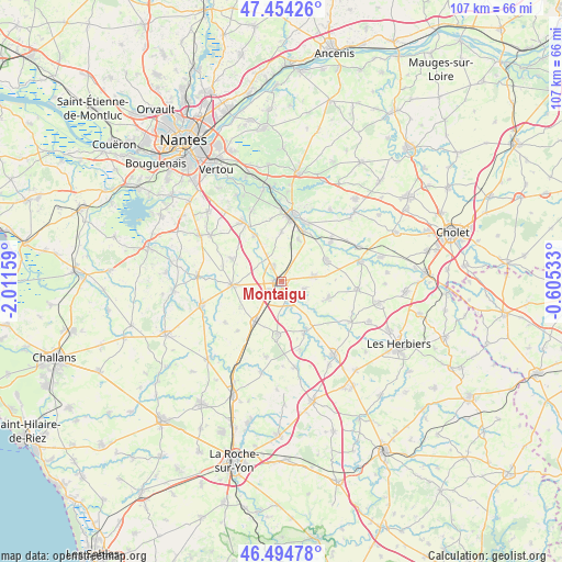
Montaigu GPS coordinates[2]
46° 58' 36.012" North, 1° 18' 30.456" West
| Map corner | latitude | longitude |
|---|---|---|
| Upper-left | 47.45426°, | -2.01159° |
| Center: | 46.97667°, | -1.30846° |
| Lower-right: | 46.49478°, | -0.60533° |
| Map W x H: | 106.7×106.7 km | = 66.3×66.3mi |
| max Lat: | 51.07786° ⇑55.5% North |
| Montaigu: | 46.97667° |
| min Lat: | ⇓44.5% South 41.3874° |
| min Long | Montaigu | max Long |
| -5.08615° | -1.30846° | 9.52242° |
| W 9.1%⇐ | ⇒90.9% E |
Elevation
Elevation of Montaigu is 47 m = 154 ft, and this is 146.7 m = 481 ft below average elevation for this country.
| Max E: |
2333 m = 7654 ft | 83.1% |
| Avg. | 193.7 m = 635 ft | |
| Montaigu | 47 m = 154 ft | |
Min E: |
-1 m = -3 ft | 16.9% |
See also: France elevation on elevation.city.
Geographical zone
Montaigu is located in North temperate zone (between Tropic of Cancer and the Arctic Circle). Distance of this North polar circle is 2177.9 km =1353.3 mi to North.| Distance of | km | miles | from Montaigu |
|---|---|---|---|
| North Pole | 4783.7 | 2972.5 | to North |
| Arctic Circle | 2177.9 | 1353.3 | to North |
| Tropic Cancer | 2617.4 | 1626.4 | to South |
| Equator | 5223.3 | 3245.6 | to South |


Nearby cities:
15 places around Montaigu: (largest is in red/bold)
• Boufféré
2.9 km =1.8 mi,  235°
235°
• Chavagnes-en-Paillers
10.4 km =6.5 mi,  155°
155°
• La Bernardière
8.7 km =5.4 mi,  21°
21°
• La Boissière-de-Montaigu
9.4 km =5.8 mi,  108°
108°
• La Bruffière
9.4 km =5.8 mi,  63°
63°
• La Guyonnière
4.6 km =2.9 mi, 106°
• La Planche
10.3 km =6.4 mi,  295°
295°
• Les Brouzils
10.2 km =6.3 mi,  185°
185°
• Remouillé
10.2 km =6.3 mi,  329°
329°
• Saint-André-Treize-Voies
9.2 km =5.7 mi, 238°
• Saint-Georges-de-Montaigu
3.6 km =2.2 mi, 160°
• Saint-Hilaire-de-Clisson
9.5 km =5.9 mi,  0°
0°
• Saint-Hilaire-de-Loulay
3.3 km =2.1 mi, 328°
• Treize-Septiers
6.1 km =3.8 mi,  80°
80°
• Vieillevigne
9.5 km =5.9 mi,  266°
266°
Sources, notices
• [Note1] Compared only with cities in France existing in our database
• [Src1] Map data: © OpenStreetMap contributors (CC-BY-SA)
• [Src2] Other city data from geonames.org with taken over terms of usage.
• [Src3] Geographical zone / Annual Mean Temperature by Robert A. Rohde @ Wikipedia
