Arches geodata
Arches (Grand Est) is a populated place; located in France in Europe/Paris (GMT+2) time zone. With population of 1,815 people, there are 5224 cities with bigger population in this country. Compared to other cities in France, 61.5% of cities are located further ↓South; 91.9% of cities are located further ←West and 85.5% of cities have lower elevation than Arches. Note1
Administrative division(s):
- Level 1: Grand Est
- Level 2: Vosges
- Level 3: Arrondissement d’Épinal
- Level 4: Arches


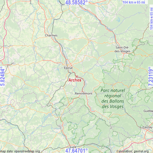
Arches GPS coordinates[2]
48° 7' 6.816" North, 6° 31' 41.016" East
| Map corner | latitude | longitude |
|---|---|---|
| Upper-left | 48.58582°, | 5.82494° |
| Center: | 48.11856°, | 6.52806° |
| Lower-right: | 47.64701°, | 7.23119° |
| Map W x H: | 104.4×104.4 km | = 64.9×64.9mi |
| max Lat: | 51.07786° ⇑38.5% North |
| Arches: | 48.11856° |
| min Lat: | ⇓61.5% South 41.3874° |
| min Long | Arches | max Long |
| -5.08615° | 6.52806° | 9.52242° |
| W 91.9%⇐ | ⇒8.1% E |
Elevation
Elevation of Arches is 352 m = 1155 ft, and this is 158.3 m = 519 ft above average elevation for this country.
| Max E: |
2333 m = 7654 ft | 14.5% |
| Arches | 352 m 1155 ft | |
| Avg. | 193.7 m = 635 ft | |
Min E: |
-1 m = -3 ft | 85.5% |
See also: France elevation on elevation.city.
Geographical zone
Arches is located in North temperate zone (between Tropic of Cancer and the Arctic Circle). Distance of this North polar circle is 2050.9 km =1274.4 mi to North.| Distance of | km | miles | from Arches |
|---|---|---|---|
| North Pole | 4656.8 | 2893.6 | to North |
| Arctic Circle | 2050.9 | 1274.4 | to North |
| Tropic Cancer | 2744.4 | 1705.3 | to South |
| Equator | 5350.3 | 3324.5 | to South |


Nearby cities:
15 places around Arches: (largest is in red/bold)
• Archettes
0.9 km =0.6 mi,  52°
52°
• Chantraine
9.1 km =5.7 mi,  310°
310°
• Cheniménil
6 km =3.7 mi,  68°
68°
• Deyvillers
9.1 km =5.7 mi,  354°
354°
• Docelles
6.9 km =4.3 mi, 65°
• Dounoux
6.4 km =4 mi,  255°
255°
• Hadol
5 km =3.1 mi,  230°
230°
• Jeuxey
9.7 km =6 mi,  342°
342°
• La Baffe
5.9 km =3.7 mi,  35°
35°
• Pouxeux
3.6 km =2.2 mi,  112°
112°
• Raon-aux-Bois
6.9 km =4.3 mi,  184°
184°
• Saint-Nabord
8.5 km =5.3 mi,  151°
151°
• Uriménil
9.7 km =6 mi, 258°
• Éloyes
6.3 km =3.9 mi, 111°
• Épinal
9.1 km =5.7 mi,  322°
322°
Sources, notices
• [Note1] Compared only with cities in France existing in our database
• [Src1] Map data: © OpenStreetMap contributors (CC-BY-SA)
• [Src2] Other city data from geonames.org with taken over terms of usage.
• [Src3] Geographical zone / Annual Mean Temperature by Robert A. Rohde @ Wikipedia
