Cerny geodata
Cerny (Île-de-France) is a populated place; located in France in Europe/Paris (GMT+2) time zone. With population of 3,365 people, there are 2891 cities with bigger population in this country. Compared to other cities in France, 67.8% of cities are located further ↓South; 52.2% of cities are located further →East and 74.1% of cities have higher elevation than Cerny. Note1
Administrative division(s):
- Level 1: Île-de-France
- Level 2: Département de l'Essonne
- Level 3: Arrondissement d'Étampes
- Level 4: Cerny


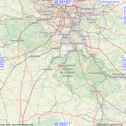
Cerny GPS coordinates[2]
48° 28' 40.656" North, 2° 19' 41.34" East
| Map corner | latitude | longitude |
|---|---|---|
| Upper-left | 48.94193°, | 1.62502° |
| Center: | 48.47796°, | 2.32815° |
| Lower-right: | 48.00971°, | 3.03127° |
| Map W x H: | 103.7×103.7 km | = 64.4×64.4mi |
| max Lat: | 51.07786° ⇑32.2% North |
| Cerny: | 48.47796° |
| min Lat: | ⇓67.8% South 41.3874° |
| min Long | Cerny | max Long |
| -5.08615° | 2.32815° | 9.52242° |
| W 47.8%⇐ | ⇒52.2% E |
Elevation
Elevation of Cerny is 69 m = 226 ft, and this is 124.7 m = 409 ft below average elevation for this country.
| Max E: |
2333 m = 7654 ft | 74.1% |
| Avg. | 193.7 m = 635 ft | |
| Cerny | 69 m = 226 ft | |
Min E: |
-1 m = -3 ft | 25.9% |
See also: France elevation on elevation.city.
Geographical zone
Cerny is located in North temperate zone (between Tropic of Cancer and the Arctic Circle). Distance of this North polar circle is 2010.9 km =1249.5 mi to North.| Distance of | km | miles | from Cerny |
|---|---|---|---|
| North Pole | 4616.8 | 2868.7 | to North |
| Arctic Circle | 2010.9 | 1249.5 | to North |
| Tropic Cancer | 2784.3 | 1730.1 | to South |
| Equator | 5390.2 | 3349.3 | to South |


Nearby cities:
15 places around Cerny: (largest is in red/bold)
• Ballancourt-sur-Essonne
6.8 km =4.2 mi,  39°
39°
• Baulne
3 km =1.9 mi,  56°
56°
• Boissy-le-Cutté
3.4 km =2.1 mi,  255°
255°
• Bouray-sur-Juine
5.1 km =3.2 mi,  335°
335°
• Boutigny-sur-Essonne
6.4 km =4 mi,  140°
140°
• Guigneville-sur-Essonne
2 km =1.2 mi,  99°
99°
• Itteville
4.3 km =2.7 mi,  15°
15°
• Janville-sur-Juine
5.8 km =3.6 mi,  313°
313°
• La Ferté-Alais
1.6 km =1 mi,  68°
68°
• Lardy
6 km =3.7 mi,  318°
318°
• Mondeville
6.7 km =4.2 mi,  77°
77°
• Saint-Vrain
7.2 km =4.5 mi,  3°
3°
• Vayres-sur-Essonne
5.2 km =3.2 mi,  162°
162°
• Videlles
7.6 km =4.7 mi, 100°
• Villeneuve-sur-Auvers
5.9 km =3.7 mi,  266°
266°
Sources, notices
• [Note1] Compared only with cities in France existing in our database
• [Src1] Map data: © OpenStreetMap contributors (CC-BY-SA)
• [Src2] Other city data from geonames.org with taken over terms of usage.
• [Src3] Geographical zone / Annual Mean Temperature by Robert A. Rohde @ Wikipedia
