Saint-Vrain geodata
Saint-Vrain (Île-de-France) is a populated place; located in France in Europe/Paris (GMT+2) time zone. With population of 2,816 people, there are 3460 cities with bigger population in this country. Compared to other cities in France, 69.3% of cities are located further ↓South; 52.1% of cities are located further →East and 74.1% of cities have higher elevation than Saint-Vrain. Note1
Administrative division(s):
- Level 1: Île-de-France
- Level 2: Département de l'Essonne
- Level 3: Arrondissement de Palaiseau
- Level 4: Saint-Vrain


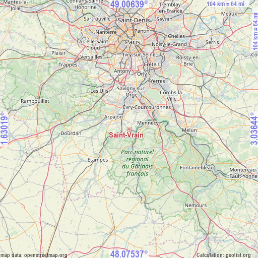
Saint-Vrain GPS coordinates[2]
48° 32' 34.872" North, 2° 19' 59.916" East
| Map corner | latitude | longitude |
|---|---|---|
| Upper-left | 49.00639°, | 1.63019° |
| Center: | 48.54302°, | 2.33331° |
| Lower-right: | 48.07537°, | 3.03644° |
| Map W x H: | 103.5×103.5 km | = 64.3×64.3mi |
| max Lat: | 51.07786° ⇑30.7% North |
| Saint-Vrain: | 48.54302° |
| min Lat: | ⇓69.3% South 41.3874° |
| min Long | Saint-Vrain | max Long |
| -5.08615° | 2.33331° | 9.52242° |
| W 47.9%⇐ | ⇒52.1% E |
Elevation
Elevation of Saint-Vrain is 69 m = 226 ft, and this is 124.7 m = 409 ft below average elevation for this country.
| Max E: |
2333 m = 7654 ft | 74.1% |
| Avg. | 193.7 m = 635 ft | |
| Saint-Vrain | 69 m = 226 ft | |
Min E: |
-1 m = -3 ft | 25.9% |
See also: France elevation on elevation.city.
Geographical zone
Saint-Vrain is located in North temperate zone (between Tropic of Cancer and the Arctic Circle). Distance of this North polar circle is 2003.7 km =1245 mi to North.| Distance of | km | miles | from Saint-Vrain |
|---|---|---|---|
| North Pole | 4609.6 | 2864.3 | to North |
| Arctic Circle | 2003.7 | 1245 | to North |
| Tropic Cancer | 2791.6 | 1734.6 | to South |
| Equator | 5397.5 | 3353.8 | to South |


Nearby cities:
15 places around Saint-Vrain: (largest is in red/bold)
• Ballancourt-sur-Essonne
4.4 km =2.7 mi,  116°
116°
• Baulne
6 km =3.7 mi,  158°
158°
• Bouray-sur-Juine
3.6 km =2.2 mi,  223°
223°
• Cheptainville
4.3 km =2.7 mi,  281°
281°
• Fontenay-le-Vicomte
4.9 km =3 mi,  83°
83°
• Guibeville
5.5 km =3.4 mi,  303°
303°
• Itteville
3.2 km =2 mi,  165°
165°
• Janville-sur-Juine
5.7 km =3.5 mi,  234°
234°
• La Ferté-Alais
6.8 km =4.2 mi, 170°
• Lardy
5.2 km =3.2 mi,  238°
238°
• Leudeville
2.6 km =1.6 mi,  349°
349°
• Marolles-en-Hurepoix
3.3 km =2.1 mi,  310°
310°
• Vert-le-Grand
3.7 km =2.3 mi,  29°
29°
• Vert-le-Petit
2.5 km =1.6 mi,  67°
67°
• Écharcon
6.6 km =4.1 mi,  59°
59°
Sources, notices
• [Note1] Compared only with cities in France existing in our database
• [Src1] Map data: © OpenStreetMap contributors (CC-BY-SA)
• [Src2] Other city data from geonames.org with taken over terms of usage.
• [Src3] Geographical zone / Annual Mean Temperature by Robert A. Rohde @ Wikipedia
