Cergy geodata
Cergy (Île-de-France) is a seat of a second-order administrative division; located in France in Europe/Paris (GMT+2) time zone. With population of 57,576 people, there are 93 cities with bigger population in this country. Compared to other cities in France, 80.5% of cities are located further ↓South; 56.1% of cities are located further →East and 83.1% of cities have higher elevation than Cergy. Note1
Administrative division(s):
- Level 1: Île-de-France
- Level 2: Département du Val-d’Oise
- Level 3: Arrondissement de Pontoise
- Level 4: Cergy


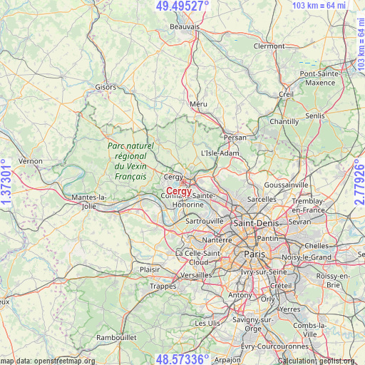
Cergy GPS coordinates[2]
49° 2' 11.22" North, 2° 4' 34.068" East
| Map corner | latitude | longitude |
|---|---|---|
| Upper-left | 49.49527°, | 1.37301° |
| Center: | 49.03645°, | 2.07613° |
| Lower-right: | 48.57336°, | 2.77926° |
| Map W x H: | 102.5×102.5 km | = 63.7×63.7mi |
| max Lat: | 51.07786° ⇑19.5% North |
| Cergy: | 49.03645° |
| min Lat: | ⇓80.5% South 41.3874° |
| min Long | Cergy | max Long |
| -5.08615° | 2.07613° | 9.52242° |
| W 43.9%⇐ | ⇒56.1% E |
Elevation
Elevation of Cergy is 47 m = 154 ft, and this is 146.7 m = 481 ft below average elevation for this country.
| Max E: |
2333 m = 7654 ft | 83.1% |
| Avg. | 193.7 m = 635 ft | |
| Cergy | 47 m = 154 ft | |
Min E: |
-1 m = -3 ft | 16.9% |
See also: Cergy elevation on elevation.city.
Geographical zone
Cergy is located in North temperate zone (between Tropic of Cancer and the Arctic Circle). Distance of this North polar circle is 1948.8 km =1210.9 mi to North.| Distance of | km | miles | from Cergy |
|---|---|---|---|
| North Pole | 4554.7 | 2830.2 | to North |
| Arctic Circle | 1948.8 | 1210.9 | to North |
| Tropic Cancer | 2846.4 | 1768.7 | to South |
| Equator | 5452.3 | 3387.9 | to South |


Nearby cities:
15 places around Cergy: (largest is in red/bold)
• Boisemont
5.3 km =3.3 mi,  255°
255°
• Cergy-Pontoise
0.3 km =0.2 mi,  26°
26°
• Conflans-Sainte-Honorine
4.2 km =2.6 mi,  158°
158°
• Courdimanche
5.5 km =3.4 mi,  268°
268°
• Ennery
4.8 km =3 mi, 26°
• Génicourt
5.9 km =3.7 mi,  354°
354°
• Jouy-le-Moutier
3.9 km =2.4 mi,  222°
222°
• Maurecourt
4.6 km =2.9 mi,  193°
193°
• Neuville-sur-Oise
2.3 km =1.4 mi,  197°
197°
• Osny
3.9 km =2.4 mi, 345°
• Pierrelaye
6 km =3.7 mi,  106°
106°
• Pontoise
2.3 km =1.4 mi,  49°
49°
• Saint-Ouen-l’Aumône
3.4 km =2.1 mi,  76°
76°
• Vauréal
3.1 km =1.9 mi, 263°
• Éragny
2.8 km =1.7 mi,  141°
141°
Sources, notices
• [Note1] Compared only with cities in France existing in our database
• [Src1] Map data: © OpenStreetMap contributors (CC-BY-SA)
• [Src2] Other city data from geonames.org with taken over terms of usage.
• [Src3] Geographical zone / Annual Mean Temperature by Robert A. Rohde @ Wikipedia
