Pontoise geodata
Pontoise (Île-de-France) is a seat of a second-order administrative division; located in France in Europe/Paris (GMT+2) time zone. With population of 30,290 people, there are 267 cities with bigger population in this country. Compared to other cities in France, 80.9% of cities are located further ↓South; 55.9% of cities are located further →East and 83.4% of cities have higher elevation than Pontoise. Note1
Administrative division(s):
- Level 1: Île-de-France
- Level 2: Département du Val-d’Oise
- Level 3: Arrondissement de Pontoise
- Level 4: Pontoise


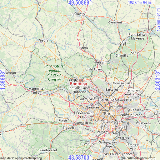
Pontoise GPS coordinates[2]
49° 3' 0" North, 2° 6' 0" East
| Map corner | latitude | longitude |
|---|---|---|
| Upper-left | 49.50869°, | 1.39688° |
| Center: | 49.05°, | 2.1° |
| Lower-right: | 48.58703°, | 2.80313° |
| Map W x H: | 102.5×102.5 km | = 63.7×63.7mi |
| max Lat: | 51.07786° ⇑19.1% North |
| Pontoise: | 49.05° |
| min Lat: | ⇓80.9% South 41.3874° |
| min Long | Pontoise | max Long |
| -5.08615° | 2.1° | 9.52242° |
| W 44.1%⇐ | ⇒55.9% E |
Elevation
Elevation of Pontoise is 46 m = 151 ft, and this is 147.7 m = 485 ft below average elevation for this country.
| Max E: |
2333 m = 7654 ft | 83.4% |
| Avg. | 193.7 m = 635 ft | |
| Pontoise | 46 m = 151 ft | |
Min E: |
-1 m = -3 ft | 16.6% |
See also: France elevation on elevation.city.
Geographical zone
Pontoise is located in North temperate zone (between Tropic of Cancer and the Arctic Circle). Distance of this North polar circle is 1947.3 km =1210 mi to North.| Distance of | km | miles | from Pontoise |
|---|---|---|---|
| North Pole | 4553.2 | 2829.2 | to North |
| Arctic Circle | 1947.3 | 1210 | to North |
| Tropic Cancer | 2847.9 | 1769.6 | to South |
| Equator | 5453.8 | 3388.8 | to South |


Nearby cities:
15 places around Pontoise: (largest is in red/bold)
• Auvers-sur-Oise
5.6 km =3.5 mi,  64°
64°
• Cergy
2.3 km =1.4 mi,  229°
229°
• Cergy-Pontoise
2 km =1.2 mi, 232°
• Conflans-Sainte-Honorine
5.4 km =3.4 mi,  182°
182°
• Ennery
2.8 km =1.7 mi,  8°
8°
• Génicourt
4.9 km =3 mi,  331°
331°
• Hérouville
6.2 km =3.9 mi,  22°
22°
• Jouy-le-Moutier
6.2 km =3.9 mi,  224°
224°
• Maurecourt
6.6 km =4.1 mi,  205°
205°
• Neuville-sur-Oise
4.4 km =2.7 mi, 213°
• Osny
3.5 km =2.2 mi,  309°
309°
• Pierrelaye
5.1 km =3.2 mi,  128°
128°
• Saint-Ouen-l’Aumône
1.7 km =1.1 mi,  114°
114°
• Vauréal
5.2 km =3.2 mi,  249°
249°
• Éragny
3.7 km =2.3 mi, 180°
Sources, notices
• [Note1] Compared only with cities in France existing in our database
• [Src1] Map data: © OpenStreetMap contributors (CC-BY-SA)
• [Src2] Other city data from geonames.org with taken over terms of usage.
• [Src3] Geographical zone / Annual Mean Temperature by Robert A. Rohde @ Wikipedia
