Carvin geodata
Carvin (Hauts-de-France) is a populated place; located in France in Europe/Paris (GMT+2) time zone. With population of 18,561 people, there are 507 cities with bigger population in this country. Compared to other cities in France, 97.2% of cities are located further ↓South; 57.2% of cities are located further ←West and 89.9% of cities have higher elevation than Carvin. Note1
Administrative division(s):
- Level 1: Hauts-de-France
- Level 2: Pas-de-Calais
- Level 3: Arrondissement de Lens
- Level 4: Carvin


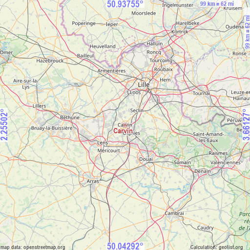
Carvin GPS coordinates[2]
50° 29' 32.46" North, 2° 57' 29.34" East
| Map corner | latitude | longitude |
|---|---|---|
| Upper-left | 50.93755°, | 2.25502° |
| Center: | 50.49235°, | 2.95815° |
| Lower-right: | 50.04292°, | 3.66127° |
| Map W x H: | 99.5×99.5 km | = 61.8×61.8mi |
| max Lat: | 51.07786° ⇑2.8% North |
| Carvin: | 50.49235° |
| min Lat: | ⇓97.2% South 41.3874° |
| min Long | Carvin | max Long |
| -5.08615° | 2.95815° | 9.52242° |
| W 57.2%⇐ | ⇒42.8% E |
Elevation
Elevation of Carvin is 30 m = 98 ft, and this is 163.7 m = 537 ft below average elevation for this country.
| Max E: |
2333 m = 7654 ft | 89.9% |
| Avg. | 193.7 m = 635 ft | |
| Carvin | 30 m = 98 ft | |
Min E: |
-1 m = -3 ft | 10.1% |
See also: France elevation on elevation.city.
Geographical zone
Carvin is located in North temperate zone (between Tropic of Cancer and the Arctic Circle). Distance of this North polar circle is 1787 km =1110.4 mi to North.| Distance of | km | miles | from Carvin |
|---|---|---|---|
| North Pole | 4392.8 | 2729.6 | to North |
| Arctic Circle | 1787 | 1110.4 | to North |
| Tropic Cancer | 3008.3 | 1869.3 | to South |
| Equator | 5614.2 | 3488.5 | to South |


Nearby cities:
15 places around Carvin: (largest is in red/bold)
• Allennes-les-Marais
5 km =3.1 mi,  356°
356°
• Annoeullin
4.5 km =2.8 mi,  335°
335°
• Bauvin
5.3 km =3.3 mi,  301°
301°
• Camphin-en-Carembault
3 km =1.9 mi,  43°
43°
• Carnin
3 km =1.9 mi,  3°
3°
• Chemy
4.8 km =3 mi,  26°
26°
• Courrières
4 km =2.5 mi,  191°
191°
• Estevelles
3.9 km =2.4 mi,  243°
243°
• Libercourt
4.2 km =2.6 mi,  103°
103°
• Meurchin
4.6 km =2.9 mi,  278°
278°
• Oignies
4.1 km =2.5 mi,  142°
142°
• Phalempin
4.9 km =3 mi,  56°
56°
• Pont-à-Vendin
5.3 km =3.3 mi,  246°
246°
• Provin
4.3 km =2.7 mi, 304°
• Épinoy
1.4 km =0.9 mi,  223°
223°
Sources, notices
• [Note1] Compared only with cities in France existing in our database
• [Src1] Map data: © OpenStreetMap contributors (CC-BY-SA)
• [Src2] Other city data from geonames.org with taken over terms of usage.
• [Src3] Geographical zone / Annual Mean Temperature by Robert A. Rohde @ Wikipedia
