Libercourt geodata
Libercourt (Hauts-de-France) is a populated place; located in France in Europe/Paris (GMT+2) time zone. With population of 8,443 people, there are 1149 cities with bigger population in this country. Compared to other cities in France, 97.1% of cities are located further ↓South; 58% of cities are located further ←West and 90.3% of cities have higher elevation than Libercourt. Note1
Administrative division(s):
- Level 1: Hauts-de-France
- Level 2: Pas-de-Calais
- Level 3: Arrondissement de Lens
- Level 4: Libercourt


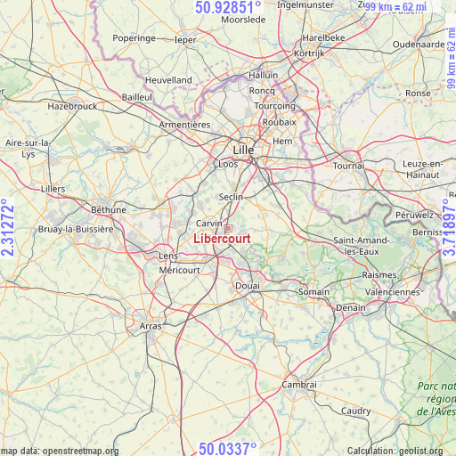
Libercourt GPS coordinates[2]
50° 28' 59.592" North, 3° 0' 57.024" East
| Map corner | latitude | longitude |
|---|---|---|
| Upper-left | 50.92851°, | 2.31272° |
| Center: | 50.48322°, | 3.01584° |
| Lower-right: | 50.0337°, | 3.71897° |
| Map W x H: | 99.5×99.5 km | = 61.8×61.8mi |
| max Lat: | 51.07786° ⇑2.9% North |
| Libercourt: | 50.48322° |
| min Lat: | ⇓97.1% South 41.3874° |
| min Long | Libercourt | max Long |
| -5.08615° | 3.01584° | 9.52242° |
| W 58%⇐ | ⇒42% E |
Elevation
Elevation of Libercourt is 29 m = 95 ft, and this is 164.7 m = 540 ft below average elevation for this country.
| Max E: |
2333 m = 7654 ft | 90.3% |
| Avg. | 193.7 m = 635 ft | |
| Libercourt | 29 m = 95 ft | |
Min E: |
-1 m = -3 ft | 9.7% |
See also: France elevation on elevation.city.
Geographical zone
Libercourt is located in North temperate zone (between Tropic of Cancer and the Arctic Circle). Distance of this North polar circle is 1788 km =1111 mi to North.| Distance of | km | miles | from Libercourt |
|---|---|---|---|
| North Pole | 4393.9 | 2730.2 | to North |
| Arctic Circle | 1788 | 1111 | to North |
| Tropic Cancer | 3007.3 | 1868.6 | to South |
| Equator | 5613.2 | 3487.9 | to South |


Nearby cities:
15 places around Libercourt: (largest is in red/bold)
• Attiches
5.4 km =3.4 mi,  37°
37°
• Camphin-en-Carembault
3.8 km =2.4 mi,  327°
327°
• Carnin
5.6 km =3.5 mi,  315°
315°
• Carvin
4.2 km =2.6 mi,  283°
283°
• Courrières
5.7 km =3.5 mi,  239°
239°
• Dourges
5.6 km =3.5 mi,  202°
202°
• La Neuville
2.5 km =1.6 mi,  64°
64°
• Oignies
2.7 km =1.7 mi,  215°
215°
• Ostricourt
3.8 km =2.4 mi,  159°
159°
• Phalempin
3.7 km =2.3 mi,  0°
0°
• Thumeries
2.9 km =1.8 mi,  104°
104°
• Tourmignies
5.5 km =3.4 mi, 61°
• Wahagnies
1.4 km =0.9 mi,  73°
73°
• Épinoy
5 km =3.1 mi,  270°
270°
• Évin-Malmaison
5 km =3.1 mi,  167°
167°
Sources, notices
• [Note1] Compared only with cities in France existing in our database
• [Src1] Map data: © OpenStreetMap contributors (CC-BY-SA)
• [Src2] Other city data from geonames.org with taken over terms of usage.
• [Src3] Geographical zone / Annual Mean Temperature by Robert A. Rohde @ Wikipedia
