Carhaix-Plouguer geodata
Carhaix-Plouguer (Brittany) is a populated place; located in France in Europe/Paris (GMT+2) time zone. With population of 8,270 people, there are 1175 cities with bigger population in this country. Compared to other cities in France, 64.1% of cities are located further ↓South; 98.4% of cities are located further →East and 53.6% of cities have lower elevation than Carhaix-Plouguer. Note1
Administrative division(s):
- Level 1: Brittany
- Level 2: Département du Finistère
- Level 3: Arrondissement de Châteaulin
- Level 4: Carhaix-Plouguer


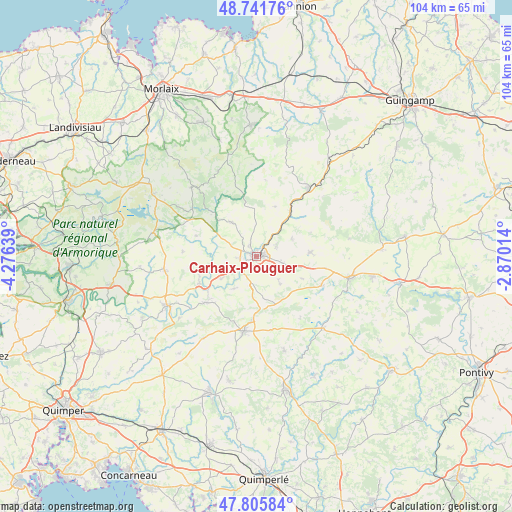
Carhaix-Plouguer GPS coordinates[2]
48° 16' 33.384" North, 3° 34' 23.736" West
| Map corner | latitude | longitude |
|---|---|---|
| Upper-left | 48.74176°, | -4.27639° |
| Center: | 48.27594°, | -3.57326° |
| Lower-right: | 47.80584°, | -2.87014° |
| Map W x H: | 104.1×104.1 km | = 64.7×64.7mi |
| max Lat: | 51.07786° ⇑35.9% North |
| Carhaix-Plouguer: | 48.27594° |
| min Lat: | ⇓64.1% South 41.3874° |
| min Long | Carhaix-Plougue | max Long |
| -5.08615° | -3.57326° | 9.52242° |
| W 1.6%⇐ | ⇒98.4% E |
Elevation
Elevation of Carhaix-Plouguer is 145 m = 476 ft, and this is 48.7 m = 160 ft below average elevation for this country.
| Max E: |
2333 m = 7654 ft | 46.4% |
| Avg. | 193.7 m = 635 ft | |
| Carhaix-Plouguer | 145 m = 476 ft | |
Min E: |
-1 m = -3 ft | 53.6% |
See also: France elevation on elevation.city.
Geographical zone
Carhaix-Plouguer is located in North temperate zone (between Tropic of Cancer and the Arctic Circle). Distance of this North polar circle is 2033.4 km =1263.5 mi to North.| Distance of | km | miles | from Carhaix-Plouguer |
|---|---|---|---|
| North Pole | 4639.3 | 2882.7 | to North |
| Arctic Circle | 2033.4 | 1263.5 | to North |
| Tropic Cancer | 2761.9 | 1716.2 | to South |
| Equator | 5367.8 | 3335.4 | to South |


Nearby cities:
15 places around Carhaix-Plouguer: (largest is in red/bold)
• Carnoët
10.9 km =6.8 mi,  20°
20°
• Cléden-Poher
8.3 km =5.2 mi,  238°
238°
• Kergloff
3.6 km =2.2 mi,  266°
266°
• Landeleau
12.7 km =7.9 mi, 244°
• Le Moustoir
5.1 km =3.2 mi,  101°
101°
• Maël-Carhaix
11.1 km =6.9 mi,  85°
85°
• Motreff
8.5 km =5.3 mi,  170°
170°
• Paule
10.6 km =6.6 mi,  114°
114°
• Plounévézel
3.3 km =2.1 mi,  323°
323°
• Plouyé
12.7 km =7.9 mi,  290°
290°
• Plévin
8.5 km =5.3 mi,  140°
140°
• Poullaouen
8.5 km =5.3 mi, 318°
• Saint-Hernin
8 km =5 mi,  214°
214°
• Treffrin
5 km =3.1 mi,  57°
57°
• Trébrivan
8 km =5 mi, 55°
Sources, notices
• [Note1] Compared only with cities in France existing in our database
• [Src1] Map data: © OpenStreetMap contributors (CC-BY-SA)
• [Src2] Other city data from geonames.org with taken over terms of usage.
• [Src3] Geographical zone / Annual Mean Temperature by Robert A. Rohde @ Wikipedia
