Plounévézel geodata
Plounévézel (Brittany) is a populated place; located in France in Europe/Paris (GMT+2) time zone. With population of 1,046 people, there are 8496 cities with bigger population in this country. Compared to other cities in France, 64.5% of cities are located further ↓South; 98.5% of cities are located further →East and 51.7% of cities have lower elevation than Plounévézel. Note1
Administrative division(s):
- Level 1: Brittany
- Level 2: Département du Finistère
- Level 3: Arrondissement de Châteaulin
- Level 4: Plounévézel


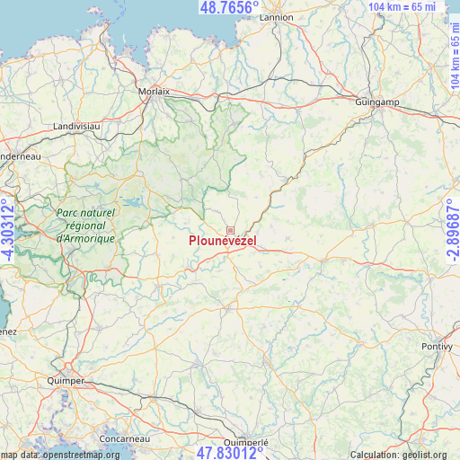
Plounévézel GPS coordinates[2]
48° 18' 0" North, 3° 36' 0" West
| Map corner | latitude | longitude |
|---|---|---|
| Upper-left | 48.7656°, | -4.30312° |
| Center: | 48.3°, | -3.6° |
| Lower-right: | 47.83012°, | -2.89687° |
| Map W x H: | 104×104 km | = 64.6×64.6mi |
| max Lat: | 51.07786° ⇑35.5% North |
| Plounévézel: | 48.3° |
| min Lat: | ⇓64.5% South 41.3874° |
| min Long | Plounévézel | max Long |
| -5.08615° | -3.6° | 9.52242° |
| W 1.5%⇐ | ⇒98.5% E |
Elevation
Elevation of Plounévézel is 138 m = 453 ft, and this is 55.7 m = 183 ft below average elevation for this country.
| Max E: |
2333 m = 7654 ft | 48.3% |
| Avg. | 193.7 m = 635 ft | |
| Plounévézel | 138 m = 453 ft | |
Min E: |
-1 m = -3 ft | 51.7% |
See also: France elevation on elevation.city.
Geographical zone
Plounévézel is located in North temperate zone (between Tropic of Cancer and the Arctic Circle). Distance of this North polar circle is 2030.7 km =1261.8 mi to North.| Distance of | km | miles | from Plounévézel |
|---|---|---|---|
| North Pole | 4636.6 | 2881 | to North |
| Arctic Circle | 2030.7 | 1261.8 | to North |
| Tropic Cancer | 2764.5 | 1717.8 | to South |
| Equator | 5370.5 | 3337.1 | to South |


Nearby cities:
15 places around Plounévézel: (largest is in red/bold)
• Carhaix-Plouguer
3.3 km =2.1 mi,  143°
143°
• Carnoët
9.5 km =5.9 mi,  38°
38°
• Cléden-Poher
8.7 km =5.4 mi,  215°
215°
• Huelgoat
12.7 km =7.9 mi,  302°
302°
• Kergloff
3.3 km =2.1 mi,  208°
208°
• Landeleau
12.5 km =7.8 mi,  229°
229°
• Le Moustoir
7.9 km =4.9 mi,  117°
117°
• Motreff
11.5 km =7.1 mi,  162°
162°
• Plouyé
10 km =6.2 mi,  280°
280°
• Plusquellec
12.7 km =7.9 mi, 42°
• Plévin
11.9 km =7.4 mi, 141°
• Poullaouen
5.2 km =3.2 mi,  315°
315°
• Saint-Hernin
9.6 km =6 mi,  194°
194°
• Treffrin
6.2 km =3.9 mi,  90°
90°
• Trébrivan
8.8 km =5.5 mi,  77°
77°
Sources, notices
• [Note1] Compared only with cities in France existing in our database
• [Src1] Map data: © OpenStreetMap contributors (CC-BY-SA)
• [Src2] Other city data from geonames.org with taken over terms of usage.
• [Src3] Geographical zone / Annual Mean Temperature by Robert A. Rohde @ Wikipedia
