Mâcon geodata
Mâcon (Bourgogne-Franche-Comté) is a seat of a second-order administrative division; located in France in Europe/Paris (GMT+2) time zone. With population of 35,484 people, there are 220 cities with bigger population in this country. Compared to other cities in France, 62.1% of cities are located further ↑North; 75.5% of cities are located further ←West and 60.9% of cities have lower elevation than Mâcon. Note1
Administrative division(s):
- Level 1: Bourgogne-Franche-Comté
- Level 2: Département de Saône-et-Loire
- Level 3: Arrondissement de Mâcon
- Level 4: Mâcon


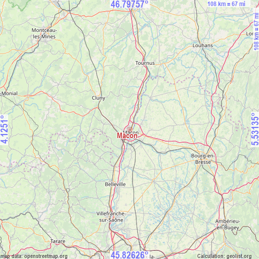
Mâcon GPS coordinates[2]
46° 18' 50.652" North, 4° 49' 41.628" East
| Map corner | latitude | longitude |
|---|---|---|
| Upper-left | 46.79757°, | 4.1251° |
| Center: | 46.31407°, | 4.82823° |
| Lower-right: | 45.82626°, | 5.53135° |
| Map W x H: | 108×108 km | = 67.1×67.1mi |
| max Lat: | 51.07786° ⇑62.1% North |
| Mâcon: | 46.31407° |
| min Lat: | ⇓37.9% South 41.3874° |
| min Long | Mâcon | max Long |
| -5.08615° | 4.82823° | 9.52242° |
| W 75.5%⇐ | ⇒24.5% E |
Elevation
Elevation of Mâcon is 174 m = 571 ft, and this is 19.7 m = 65 ft below average elevation for this country.
| Max E: |
2333 m = 7654 ft | 39.1% |
| Avg. | 193.7 m = 635 ft | |
| Mâcon | 174 m = 571 ft | |
Min E: |
-1 m = -3 ft | 60.9% |
See also: France elevation on elevation.city.
Geographical zone
Mâcon is located in North temperate zone (between Tropic of Cancer and the Arctic Circle). Distance of this North polar circle is 2251.5 km =1399 mi to North.| Distance of | km | miles | from Mâcon |
|---|---|---|---|
| North Pole | 4857.4 | 3018.2 | to North |
| Arctic Circle | 2251.5 | 1399 | to North |
| Tropic Cancer | 2543.7 | 1580.6 | to South |
| Equator | 5149.6 | 3199.8 | to South |


Nearby cities:
15 places around Mâcon: (largest is in red/bold)
• Charnay-lès-Mâcon
3.4 km =2.1 mi,  257°
257°
• Crottet
6.6 km =4.1 mi,  129°
129°
• Davayé
6.6 km =4.1 mi, 259°
• Feillens
5.3 km =3.3 mi,  65°
65°
• Grièges
6.6 km =4.1 mi,  166°
166°
• Hurigny
4.4 km =2.7 mi,  326°
326°
• Manziat
7.9 km =4.9 mi,  48°
48°
• Pont-de-Veyle
7.3 km =4.5 mi,  142°
142°
• Prissé
6.5 km =4 mi,  277°
277°
• Replonges
4.5 km =2.8 mi,  109°
109°
• Saint-André-de-Bâgé
7.4 km =4.6 mi,  101°
101°
• Saint-Laurent-sur-Saône
1.4 km =0.9 mi, 134°
• Saint-Martin-Belle-Roche
8 km =5 mi,  15°
15°
• Sancé
2.8 km =1.7 mi,  3°
3°
• Vinzelles
6.5 km =4 mi,  225°
225°
Sources, notices
• [Note1] Compared only with cities in France existing in our database
• [Src1] Map data: © OpenStreetMap contributors (CC-BY-SA)
• [Src2] Other city data from geonames.org with taken over terms of usage.
• [Src3] Geographical zone / Annual Mean Temperature by Robert A. Rohde @ Wikipedia
