Sancé geodata
Sancé (Bourgogne-Franche-Comté) is a populated place; located in France in Europe/Paris (GMT+2) time zone. With population of 1,843 people, there are 5141 cities with bigger population in this country. Compared to other cities in France, 61.8% of cities are located further ↑North; 75.5% of cities are located further ←West and 65% of cities have lower elevation than Sancé. Note1
Administrative division(s):
- Level 1: Bourgogne-Franche-Comté
- Level 2: Département de Saône-et-Loire
- Level 3: Arrondissement de Mâcon
- Level 4: Sancé


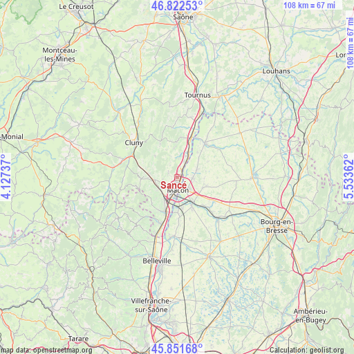
Sancé GPS coordinates[2]
46° 20' 21.336" North, 4° 49' 49.764" East
| Map corner | latitude | longitude |
|---|---|---|
| Upper-left | 46.82253°, | 4.12737° |
| Center: | 46.33926°, | 4.83049° |
| Lower-right: | 45.85168°, | 5.53362° |
| Map W x H: | 107.9×107.9 km | = 67×67mi |
| max Lat: | 51.07786° ⇑61.8% North |
| Sancé: | 46.33926° |
| min Lat: | ⇓38.2% South 41.3874° |
| min Long | Sancé | max Long |
| -5.08615° | 4.83049° | 9.52242° |
| W 75.5%⇐ | ⇒24.5% E |
Elevation
Elevation of Sancé is 194 m = 636 ft, and this is 0.30000000000001 m = 1 ft above average elevation for this country.
| Max E: |
2333 m = 7654 ft | 35% |
| Sancé | 194 m 636 ft | |
| Avg. | 193.7 m = 635 ft | |
Min E: |
-1 m = -3 ft | 65% |
See also: France elevation on elevation.city.
Geographical zone
Sancé is located in North temperate zone (between Tropic of Cancer and the Arctic Circle). Distance of this North polar circle is 2248.7 km =1397.3 mi to North.| Distance of | km | miles | from Sancé |
|---|---|---|---|
| North Pole | 4854.6 | 3016.5 | to North |
| Arctic Circle | 2248.7 | 1397.3 | to North |
| Tropic Cancer | 2546.5 | 1582.3 | to South |
| Equator | 5152.4 | 3201.6 | to South |


Nearby cities:
15 places around Sancé: (largest is in red/bold)
• Bâgé-le-Châtel
8.5 km =5.3 mi,  113°
113°
• Charnay-lès-Mâcon
5 km =3.1 mi,  224°
224°
• Davayé
7.8 km =4.8 mi,  239°
239°
• Feillens
4.7 km =2.9 mi,  96°
96°
• Hurigny
2.7 km =1.7 mi,  288°
288°
• Laizé
6.5 km =4 mi,  343°
343°
• Manziat
6.3 km =3.9 mi,  67°
67°
• Mâcon
2.8 km =1.7 mi,  183°
183°
• Prissé
6.9 km =4.3 mi,  253°
253°
• Replonges
5.9 km =3.7 mi,  136°
136°
• Saint-André-de-Bâgé
8.3 km =5.2 mi,  120°
120°
• Saint-Laurent-sur-Saône
3.9 km =2.4 mi,  167°
167°
• Saint-Martin-Belle-Roche
5.2 km =3.2 mi,  21°
21°
• Senozan
6.8 km =4.2 mi, 21°
• Verzé
8.4 km =5.2 mi,  300°
300°
Sources, notices
• [Note1] Compared only with cities in France existing in our database
• [Src1] Map data: © OpenStreetMap contributors (CC-BY-SA)
• [Src2] Other city data from geonames.org with taken over terms of usage.
• [Src3] Geographical zone / Annual Mean Temperature by Robert A. Rohde @ Wikipedia
