Bussac-Forêt geodata
Bussac-Forêt (Nouvelle-Aquitaine) is a populated place; located in France in Europe/Paris (GMT+2) time zone. With population of 933 people, there are 9360 cities with bigger population in this country. Compared to other cities in France, 77.3% of cities are located further ↑North; 81.7% of cities are located further →East and 77% of cities have higher elevation than Bussac-Forêt. Note1
Administrative division(s):
- Level 1: Nouvelle-Aquitaine
- Level 2: Charente-Maritime
- Level 3: Arrondissement de Jonzac
- Level 4: Bussac-Forêt


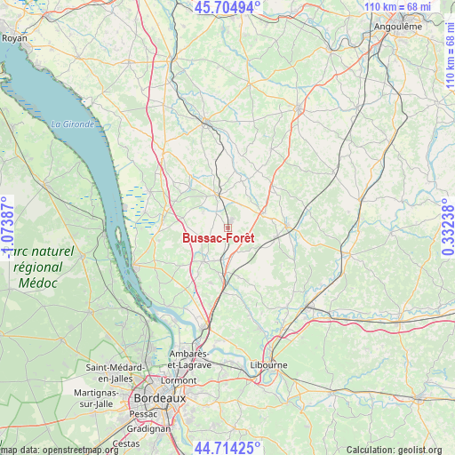
Bussac-Forêt GPS coordinates[2]
45° 12' 42.3" North, 0° 22' 14.664" West
| Map corner | latitude | longitude |
|---|---|---|
| Upper-left | 45.70494°, | -1.07387° |
| Center: | 45.21175°, | -0.37074° |
| Lower-right: | 44.71425°, | 0.33238° |
| Map W x H: | 110.2×110.2 km | = 68.5×68.5mi |
| max Lat: | 51.07786° ⇑77.3% North |
| Bussac-Forêt: | 45.21175° |
| min Lat: | ⇓22.7% South 41.3874° |
| min Long | Bussac-Forêt | max Long |
| -5.08615° | -0.37074° | 9.52242° |
| W 18.3%⇐ | ⇒81.7% E |
Elevation
Elevation of Bussac-Forêt is 62 m = 203 ft, and this is 131.7 m = 432 ft below average elevation for this country.
| Max E: |
2333 m = 7654 ft | 77% |
| Avg. | 193.7 m = 635 ft | |
| Bussac-Forêt | 62 m = 203 ft | |
Min E: |
-1 m = -3 ft | 23% |
See also: France elevation on elevation.city.
Geographical zone
Bussac-Forêt is located in North temperate zone (between Tropic of Cancer and the Arctic Circle). Distance of this North polar circle is 2374.1 km =1475.2 mi to North.| Distance of | km | miles | from Bussac-Forêt |
|---|---|---|---|
| North Pole | 4980 | 3094.4 | to North |
| Arctic Circle | 2374.1 | 1475.2 | to North |
| Tropic Cancer | 2421.2 | 1504.5 | to South |
| Equator | 5027.1 | 3123.7 | to South |


Nearby cities:
15 places around Bussac-Forêt: (largest is in red/bold)
• Bedenac
7.5 km =4.7 mi,  132°
132°
• Cavignac
12.4 km =7.7 mi,  186°
186°
• Chepniers
7 km =4.3 mi,  52°
52°
• Civrac-de-Blaye
12.5 km =7.8 mi,  207°
207°
• Clérac
12.5 km =7.8 mi,  104°
104°
• Donnezac
6.9 km =4.3 mi,  303°
303°
• Laruscade
11 km =6.8 mi,  164°
164°
• Marcillac
13.6 km =8.5 mi, 297°
• Montendre
8.6 km =5.3 mi,  341°
341°
• Montlieu-la-Garde
10.4 km =6.5 mi,  65°
65°
• Orignolles
11 km =6.8 mi,  77°
77°
• Reignac
10.9 km =6.8 mi,  283°
283°
• Saint-Mariens
10.9 km =6.8 mi, 192°
• Saint-Savin
9.3 km =5.8 mi,  222°
222°
• Saint-Yzan-de-Soudiac
8.5 km =5.3 mi,  201°
201°
Sources, notices
• [Note1] Compared only with cities in France existing in our database
• [Src1] Map data: © OpenStreetMap contributors (CC-BY-SA)
• [Src2] Other city data from geonames.org with taken over terms of usage.
• [Src3] Geographical zone / Annual Mean Temperature by Robert A. Rohde @ Wikipedia
