Chepniers geodata
Chepniers (Nouvelle-Aquitaine) is a populated place; located in France in Europe/Paris (GMT+2) time zone. With population of 686 people, there are 12000 cities with bigger population in this country. Compared to other cities in France, 76.9% of cities are located further ↑North; 80.9% of cities are located further →East and 61.2% of cities have higher elevation than Chepniers. Note1
Administrative division(s):
- Level 1: Nouvelle-Aquitaine
- Level 2: Charente-Maritime
- Level 3: Arrondissement de Jonzac
- Level 4: Chepniers


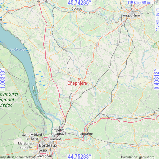
Chepniers GPS coordinates[2]
45° 15' 0" North, 0° 18' 0" West
| Map corner | latitude | longitude |
|---|---|---|
| Upper-left | 45.74285°, | -1.00313° |
| Center: | 45.25°, | -0.3° |
| Lower-right: | 44.75283°, | 0.40312° |
| Map W x H: | 110.1×110.1 km | = 68.4×68.4mi |
| max Lat: | 51.07786° ⇑76.9% North |
| Chepniers: | 45.25° |
| min Lat: | ⇓23.1% South 41.3874° |
| min Long | Chepniers | max Long |
| -5.08615° | -0.3° | 9.52242° |
| W 19.1%⇐ | ⇒80.9% E |
Elevation
Elevation of Chepniers is 99 m = 325 ft, and this is 94.7 m = 311 ft below average elevation for this country.
| Max E: |
2333 m = 7654 ft | 61.2% |
| Avg. | 193.7 m = 635 ft | |
| Chepniers | 99 m = 325 ft | |
Min E: |
-1 m = -3 ft | 38.8% |
See also: France elevation on elevation.city.
Geographical zone
Chepniers is located in North temperate zone (between Tropic of Cancer and the Arctic Circle). Distance of this North polar circle is 2369.8 km =1472.5 mi to North.| Distance of | km | miles | from Chepniers |
|---|---|---|---|
| North Pole | 4975.7 | 3091.8 | to North |
| Arctic Circle | 2369.8 | 1472.5 | to North |
| Tropic Cancer | 2425.4 | 1507.1 | to South |
| Equator | 5031.3 | 3126.3 | to South |


Nearby cities:
15 places around Chepniers: (largest is in red/bold)
• Baignes-Sainte-Radegonde
15.7 km =9.8 mi,  19°
19°
• Bedenac
9.3 km =5.8 mi,  180°
180°
• Bussac-Forêt
7 km =4.3 mi,  232°
232°
• Cercoux
15.2 km =9.4 mi,  148°
148°
• Chevanceaux
7.6 km =4.7 mi,  43°
43°
• Clérac
9.9 km =6.2 mi,  138°
138°
• Donnezac
11.3 km =7 mi,  267°
267°
• Laruscade
15.1 km =9.4 mi,  189°
189°
• Le Fouilloux
16.2 km =10.1 mi,  117°
117°
• Montendre
9.2 km =5.7 mi,  294°
294°
• Montguyon
9.9 km =6.2 mi,  112°
112°
• Montlieu-la-Garde
3.9 km =2.4 mi,  90°
90°
• Orignolles
5.5 km =3.4 mi, 109°
• Saint-Savin
16.2 km =10.1 mi, 226°
• Saint-Yzan-de-Soudiac
14.9 km =9.3 mi,  215°
215°
Sources, notices
• [Note1] Compared only with cities in France existing in our database
• [Src1] Map data: © OpenStreetMap contributors (CC-BY-SA)
• [Src2] Other city data from geonames.org with taken over terms of usage.
• [Src3] Geographical zone / Annual Mean Temperature by Robert A. Rohde @ Wikipedia
