Buhl geodata
Buhl (Grand Est) is a populated place; located in France in Europe/Paris (GMT+2) time zone. With population of 3,223 people, there are 3027 cities with bigger population in this country. Compared to other cities in France, 58% of cities are located further ↓South; 95.7% of cities are located further ←West and 84.6% of cities have lower elevation than Buhl. Note1
Administrative division(s):
- Level 1: Grand Est
- Level 2: Haut-Rhin
- Level 3: Arrondissement de Thann-Guebwiller
- Level 4: Buhl


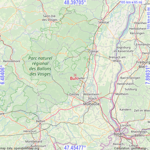
Buhl GPS coordinates[2]
47° 55' 41.016" North, 7° 11' 13.884" East
| Map corner | latitude | longitude |
|---|---|---|
| Upper-left | 48.39705°, | 6.48406° |
| Center: | 47.92806°, | 7.18719° |
| Lower-right: | 47.45477°, | 7.89031° |
| Map W x H: | 104.8×104.8 km | = 65.1×65.1mi |
| max Lat: | 51.07786° ⇑42% North |
| Buhl: | 47.92806° |
| min Lat: | ⇓58% South 41.3874° |
| min Long | Buhl | max Long |
| -5.08615° | 7.18719° | 9.52242° |
| W 95.7%⇐ | ⇒4.3% E |
Elevation
Elevation of Buhl is 341 m = 1119 ft, and this is 147.3 m = 483 ft above average elevation for this country.
| Max E: |
2333 m = 7654 ft | 15.4% |
| Buhl | 341 m 1119 ft | |
| Avg. | 193.7 m = 635 ft | |
Min E: |
-1 m = -3 ft | 84.6% |
See also: France elevation on elevation.city.
Geographical zone
Buhl is located in North temperate zone (between Tropic of Cancer and the Arctic Circle). Distance of this North polar circle is 2072.1 km =1287.5 mi to North.| Distance of | km | miles | from Buhl |
|---|---|---|---|
| North Pole | 4678 | 2906.8 | to North |
| Arctic Circle | 2072.1 | 1287.5 | to North |
| Tropic Cancer | 2723.2 | 1692.1 | to South |
| Equator | 5329.1 | 3311.3 | to South |


Nearby cities:
15 places around Buhl: (largest is in red/bold)
• Bergholtz
4.6 km =2.9 mi,  105°
105°
• Guebwiller
1.6 km =1 mi,  142°
142°
• Gundolsheim
8 km =5 mi,  88°
88°
• Hartmannswiller
7.7 km =4.8 mi,  164°
164°
• Issenheim
5.6 km =3.5 mi,  119°
119°
• Jungholtz
4.9 km =3 mi,  172°
172°
• Lautenbach
2.6 km =1.6 mi,  302°
302°
• Lautenbachzell
3.4 km =2.1 mi, 295°
• Linthal
5.4 km =3.4 mi, 300°
• Orschwihr
3.5 km =2.2 mi,  77°
77°
• Osenbach
6.8 km =4.2 mi,  19°
19°
• Soultz-Haut-Rhin
5.4 km =3.4 mi, 144°
• Soultzmatt
5.3 km =3.3 mi,  44°
44°
• Westhalten
6.3 km =3.9 mi,  59°
59°
• Wuenheim
6.2 km =3.9 mi, 166°
Sources, notices
• [Note1] Compared only with cities in France existing in our database
• [Src1] Map data: © OpenStreetMap contributors (CC-BY-SA)
• [Src2] Other city data from geonames.org with taken over terms of usage.
• [Src3] Geographical zone / Annual Mean Temperature by Robert A. Rohde @ Wikipedia
