Hartmannswiller geodata
Hartmannswiller (Grand Est) is a populated place; located in France in Europe/Paris (GMT+2) time zone. With population of 674 people, there are 12156 cities with bigger population in this country. Compared to other cities in France, 56.8% of cities are located further ↓South; 95.9% of cities are located further ←West and 75.8% of cities have lower elevation than Hartmannswiller. Note1
Administrative division(s):
- Level 1: Grand Est
- Level 2: Haut-Rhin
- Level 3: Arrondissement de Thann-Guebwiller
- Level 4: Hartmannswiller


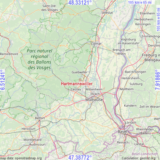
Hartmannswiller GPS coordinates[2]
47° 51' 41.796" North, 7° 12' 55.908" East
| Map corner | latitude | longitude |
|---|---|---|
| Upper-left | 48.33121°, | 6.51241° |
| Center: | 47.86161°, | 7.21553° |
| Lower-right: | 47.38772°, | 7.91866° |
| Map W x H: | 104.9×104.9 km | = 65.2×65.2mi |
| max Lat: | 51.07786° ⇑43.2% North |
| Hartmannswiller: | 47.86161° |
| min Lat: | ⇓56.8% South 41.3874° |
| min Long | Hartmannswiller | max Long |
| -5.08615° | 7.21553° | 9.52242° |
| W 95.9%⇐ | ⇒4.1% E |
Elevation
Elevation of Hartmannswiller is 255 m = 837 ft, and this is 61.3 m = 201 ft above average elevation for this country.
| Max E: |
2333 m = 7654 ft | 24.2% |
| Hartmannswiller | 255 m 837 ft | |
| Avg. | 193.7 m = 635 ft | |
Min E: |
-1 m = -3 ft | 75.8% |
See also: France elevation on elevation.city.
Geographical zone
Hartmannswiller is located in North temperate zone (between Tropic of Cancer and the Arctic Circle). Distance of this North polar circle is 2079.5 km =1292.1 mi to North.| Distance of | km | miles | from Hartmannswiller |
|---|---|---|---|
| North Pole | 4685.3 | 2911.3 | to North |
| Arctic Circle | 2079.5 | 1292.1 | to North |
| Tropic Cancer | 2715.8 | 1687.5 | to South |
| Equator | 5321.7 | 3306.8 | to South |


Nearby cities:
15 places around Hartmannswiller: (largest is in red/bold)
• Bergholtz
6.5 km =4 mi,  20°
20°
• Berrwiller
1.3 km =0.8 mi,  168°
168°
• Bollwiller
3.5 km =2.2 mi,  96°
96°
• Cernay
6.4 km =4 mi,  206°
206°
• Feldkirch
4.4 km =2.7 mi,  85°
85°
• Guebwiller
6.2 km =3.9 mi,  349°
349°
• Issenheim
5.4 km =3.4 mi,  30°
30°
• Jungholtz
2.9 km =1.8 mi,  330°
330°
• Raedersheim
5.8 km =3.6 mi,  58°
58°
• Soultz-Haut-Rhin
3.1 km =1.9 mi, 18°
• Staffelfelden
4.8 km =3 mi,  144°
144°
• Uffholtz
5.3 km =3.3 mi, 211°
• Wattwiller
4 km =2.5 mi,  225°
225°
• Wittelsheim
6.1 km =3.8 mi,  161°
161°
• Wuenheim
1.5 km =0.9 mi, 333°
Sources, notices
• [Note1] Compared only with cities in France existing in our database
• [Src1] Map data: © OpenStreetMap contributors (CC-BY-SA)
• [Src2] Other city data from geonames.org with taken over terms of usage.
• [Src3] Geographical zone / Annual Mean Temperature by Robert A. Rohde @ Wikipedia
