Buchelay geodata
Buchelay (Île-de-France) is a populated place; located in France in Europe/Paris (GMT+2) time zone. With population of 2,325 people, there are 4153 cities with bigger population in this country. Compared to other cities in France, 79.2% of cities are located further ↓South; 60.8% of cities are located further →East and 74.1% of cities have higher elevation than Buchelay. Note1
Administrative division(s):
- Level 1: Île-de-France
- Level 2: Yvelines
- Level 3: Arrondissement de Mantes-la-Jolie
- Level 4: Buchelay


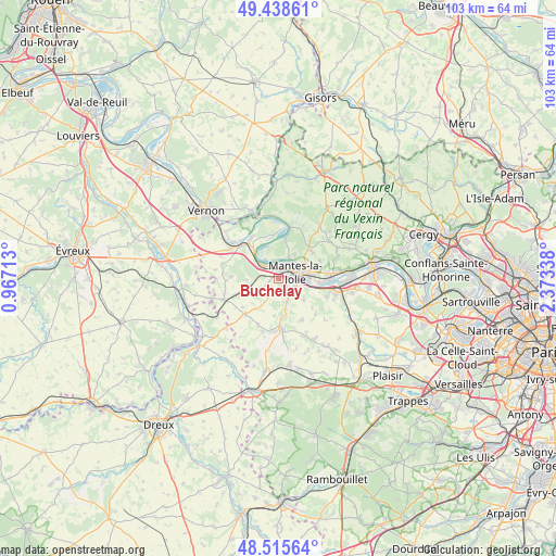
Buchelay GPS coordinates[2]
48° 58' 45.336" North, 1° 40' 12.936" East
| Map corner | latitude | longitude |
|---|---|---|
| Upper-left | 49.43861°, | 0.96713° |
| Center: | 48.97926°, | 1.67026° |
| Lower-right: | 48.51564°, | 2.37338° |
| Map W x H: | 102.6×102.6 km | = 63.8×63.8mi |
| max Lat: | 51.07786° ⇑20.8% North |
| Buchelay: | 48.97926° |
| min Lat: | ⇓79.2% South 41.3874° |
| min Long | Buchelay | max Long |
| -5.08615° | 1.67026° | 9.52242° |
| W 39.2%⇐ | ⇒60.8% E |
Elevation
Elevation of Buchelay is 69 m = 226 ft, and this is 124.7 m = 409 ft below average elevation for this country.
| Max E: |
2333 m = 7654 ft | 74.1% |
| Avg. | 193.7 m = 635 ft | |
| Buchelay | 69 m = 226 ft | |
Min E: |
-1 m = -3 ft | 25.9% |
See also: France elevation on elevation.city.
Geographical zone
Buchelay is located in North temperate zone (between Tropic of Cancer and the Arctic Circle). Distance of this North polar circle is 1955.2 km =1214.9 mi to North.| Distance of | km | miles | from Buchelay |
|---|---|---|---|
| North Pole | 4561.1 | 2834.1 | to North |
| Arctic Circle | 1955.2 | 1214.9 | to North |
| Tropic Cancer | 2840.1 | 1764.8 | to South |
| Equator | 5446 | 3384 | to South |


Nearby cities:
15 places around Buchelay: (largest is in red/bold)
• Auffreville-Brasseuil
4 km =2.5 mi,  134°
134°
• Breuil-Bois-Robert
5.1 km =3.2 mi,  137°
137°
• Follainville-Dennemont
5.7 km =3.5 mi,  33°
33°
• Guernes
4.3 km =2.7 mi,  325°
325°
• Guerville
6.1 km =3.8 mi, 130°
• Jouy-Mauvoisin
1.7 km =1.1 mi,  256°
256°
• Limay
5.5 km =3.4 mi,  70°
70°
• Magnanville
1.4 km =0.9 mi,  154°
154°
• Mantes-la-Jolie
3.6 km =2.2 mi, 69°
• Mantes-la-Ville
2.4 km =1.5 mi,  104°
104°
• Rosny-sur-Seine
3.5 km =2.2 mi,  306°
306°
• Saint-Martin-la-Garenne
7 km =4.3 mi,  11°
11°
• Soindres
2.4 km =1.5 mi,  171°
171°
• Vert
4.3 km =2.7 mi,  158°
158°
• Villette
6 km =3.7 mi, 164°
Sources, notices
• [Note1] Compared only with cities in France existing in our database
• [Src1] Map data: © OpenStreetMap contributors (CC-BY-SA)
• [Src2] Other city data from geonames.org with taken over terms of usage.
• [Src3] Geographical zone / Annual Mean Temperature by Robert A. Rohde @ Wikipedia
