Bransles geodata
Bransles (Île-de-France) is a populated place; located in France in Europe/Paris (GMT+2) time zone. With population of 511 people, there are 15016 cities with bigger population in this country. Compared to other cities in France, 62% of cities are located further ↓South; 55.4% of cities are located further ←West and 57.9% of cities have higher elevation than Bransles. Note1
Administrative division(s):
- Level 1: Île-de-France
- Level 2: Seine-et-Marne
- Level 3: Arrondissement de Fontainebleau
- Level 4: Bransles


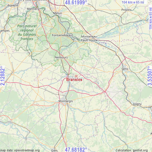
Bransles GPS coordinates[2]
48° 9' 10.98" North, 2° 49' 55.02" East
| Map corner | latitude | longitude |
|---|---|---|
| Upper-left | 48.61999°, | 2.12882° |
| Center: | 48.15305°, | 2.83195° |
| Lower-right: | 47.68182°, | 3.53507° |
| Map W x H: | 104.3×104.3 km | = 64.8×64.8mi |
| max Lat: | 51.07786° ⇑38% North |
| Bransles: | 48.15305° |
| min Lat: | ⇓62% South 41.3874° |
| min Long | Bransles | max Long |
| -5.08615° | 2.83195° | 9.52242° |
| W 55.4%⇐ | ⇒44.6% E |
Elevation
Elevation of Bransles is 108 m = 354 ft, and this is 85.7 m = 281 ft below average elevation for this country.
| Max E: |
2333 m = 7654 ft | 57.9% |
| Avg. | 193.7 m = 635 ft | |
| Bransles | 108 m = 354 ft | |
Min E: |
-1 m = -3 ft | 42.1% |
See also: France elevation on elevation.city.
Geographical zone
Bransles is located in North temperate zone (between Tropic of Cancer and the Arctic Circle). Distance of this North polar circle is 2047.1 km =1272 mi to North.| Distance of | km | miles | from Bransles |
|---|---|---|---|
| North Pole | 4652.9 | 2891.2 | to North |
| Arctic Circle | 2047.1 | 1272 | to North |
| Tropic Cancer | 2748.2 | 1707.7 | to South |
| Equator | 5354.1 | 3326.9 | to South |


Nearby cities:
15 places around Bransles: (largest is in red/bold)
• Bagneaux-sur-Loing
12.9 km =8 mi,  313°
313°
• Bazoches-sur-le-Betz
11.8 km =7.3 mi,  100°
100°
• Chaintreaux
5.2 km =3.2 mi,  350°
350°
• Château-Landon
10 km =6.2 mi,  266°
266°
• Dordives
4.9 km =3 mi,  256°
256°
• Fontenay-sur-Loing
6.9 km =4.3 mi,  217°
217°
• Griselles
7.8 km =4.8 mi,  181°
181°
• La Selle-sur-le-Bied
11 km =6.8 mi,  153°
153°
• Lorrez-le-Bocage-Préaux
10.3 km =6.4 mi,  29°
29°
• Nanteau-sur-Lunain
11.6 km =7.2 mi, 352°
• Nargis
7.3 km =4.5 mi,  230°
230°
• Poligny
10.2 km =6.3 mi,  320°
320°
• Souppes-sur-Loing
7.9 km =4.9 mi,  294°
294°
• Villemaréchal
12.9 km =8 mi,  11°
11°
• Égreville
4 km =2.5 mi,  49°
49°
Sources, notices
• [Note1] Compared only with cities in France existing in our database
• [Src1] Map data: © OpenStreetMap contributors (CC-BY-SA)
• [Src2] Other city data from geonames.org with taken over terms of usage.
• [Src3] Geographical zone / Annual Mean Temperature by Robert A. Rohde @ Wikipedia
