Lorrez-le-Bocage-Préaux geodata
Lorrez-le-Bocage-Préaux (Île-de-France) is a populated place; located in France in Europe/Paris (GMT+2) time zone. With population of 1,391 people, there are 6643 cities with bigger population in this country. Compared to other cities in France, 63.3% of cities are located further ↓South; 56.4% of cities are located further ←West and 58.3% of cities have higher elevation than Lorrez-le-Bocage-Préaux. Note1
Administrative division(s):
- Level 1: Île-de-France
- Level 2: Seine-et-Marne
- Level 3: Arrondissement de Fontainebleau
- Level 4: Lorrez-le-Bocage-Préaux
Current local time in Lorrez-le-Bocage-Préaux:
09:59 AM, SaturdayDifference from your time zone: hours


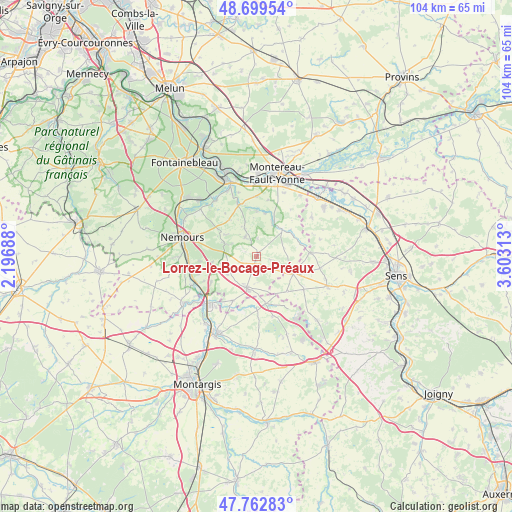
Lorrez-le-Bocage-Préaux GPS coordinates[2]
48° 13' 59.988" North, 2° 54' 0" East
| Map corner | latitude | longitude |
|---|---|---|
| Upper-left | 48.69954°, | 2.19688° |
| Center: | 48.23333°, | 2.9° |
| Lower-right: | 47.76283°, | 3.60313° |
| Map W x H: | 104.2×104.1 km | = 64.7×64.7mi |
| max Lat: | 51.07786° ⇑36.7% North |
| Lorrez-le-Bocage-Préaux: | 48.23333° |
| min Lat: | ⇓63.3% South 41.3874° |
| min Long | Lorrez-le-Bocag | max Long |
| -5.08615° | 2.9° | 9.52242° |
| W 56.4%⇐ | ⇒43.6% E |
Elevation
Elevation of Lorrez-le-Bocage-Préaux is 107 m = 351 ft, and this is 86.7 m = 284 ft below average elevation for this country.
| Max E: |
2333 m = 7654 ft | 58.3% |
| Avg. | 193.7 m = 635 ft | |
| Lorrez-le-Bocage-Préaux | 107 m = 351 ft | |
Min E: |
-1 m = -3 ft | 41.7% |
See also: France elevation on elevation.city.
Geographical zone
Lorrez-le-Bocage-Préaux is located in North temperate zone (between Tropic of Cancer and the Arctic Circle). Distance of this North polar circle is 2038.1 km =1266.4 mi to North.| Distance of | km | miles | from Lorrez-le-Bocage-Préaux |
|---|---|---|---|
| North Pole | 4644 | 2885.6 | to North |
| Arctic Circle | 2038.1 | 1266.4 | to North |
| Tropic Cancer | 2757.1 | 1713.2 | to South |
| Equator | 5363 | 3332.4 | to South |


Nearby cities:
15 places around Lorrez-le-Bocage-Préaux: (largest is in red/bold)
• Blennes
9.5 km =5.9 mi,  73°
73°
• Bransles
10.3 km =6.4 mi,  209°
209°
• Chaintreaux
7 km =4.3 mi,  236°
236°
• Chéroy
8.3 km =5.2 mi,  116°
116°
• Dormelles
9.1 km =5.7 mi,  359°
359°
• Flagy
8.9 km =5.5 mi,  10°
10°
• Nanteau-sur-Lunain
7.1 km =4.4 mi,  291°
291°
• Noisy-Rudignon
11.6 km =7.2 mi, 11°
• Nonville
9.6 km =6 mi,  304°
304°
• Thoury-Férottes
7.4 km =4.6 mi,  24°
24°
• Villecerf
11.2 km =7 mi,  339°
339°
• Villemaréchal
4.5 km =2.8 mi,  326°
326°
• Villemer
9.4 km =5.8 mi,  323°
323°
• Voulx
7.4 km =4.6 mi,  42°
42°
• Égreville
6.7 km =4.2 mi,  197°
197°
Sources, notices
• [Note1] Compared only with cities in France existing in our database
• [Src1] Map data: © OpenStreetMap contributors (CC-BY-SA)
• [Src2] Other city data from geonames.org with taken over terms of usage.
• [Src3] Geographical zone / Annual Mean Temperature by Robert A. Rohde @ Wikipedia
