Boutigny geodata
Boutigny (Île-de-France) is a populated place; located in France in Europe/Paris (GMT+2) time zone. With population of 896 people, there are 9692 cities with bigger population in this country. Compared to other cities in France, 78% of cities are located further ↓South; 56.8% of cities are located further ←West and 52.6% of cities have higher elevation than Boutigny. Note1
Administrative division(s):
- Level 1: Île-de-France
- Level 2: Seine-et-Marne
- Level 3: Arrondissement de Meaux
- Level 4: Boutigny


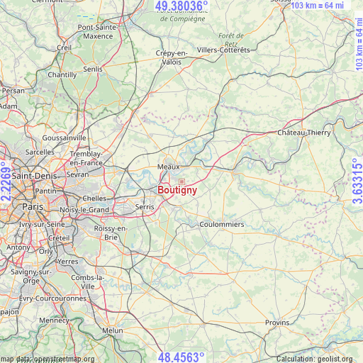
Boutigny GPS coordinates[2]
48° 55' 13.692" North, 2° 55' 48.108" East
| Map corner | latitude | longitude |
|---|---|---|
| Upper-left | 49.38036°, | 2.2269° |
| Center: | 48.92047°, | 2.93003° |
| Lower-right: | 48.4563°, | 3.63315° |
| Map W x H: | 102.7×102.7 km | = 63.8×63.8mi |
| max Lat: | 51.07786° ⇑22% North |
| Boutigny: | 48.92047° |
| min Lat: | ⇓78% South 41.3874° |
| min Long | Boutigny | max Long |
| -5.08615° | 2.93003° | 9.52242° |
| W 56.8%⇐ | ⇒43.2% E |
Elevation
Elevation of Boutigny is 123 m = 404 ft, and this is 70.7 m = 232 ft below average elevation for this country.
| Max E: |
2333 m = 7654 ft | 52.6% |
| Avg. | 193.7 m = 635 ft | |
| Boutigny | 123 m = 404 ft | |
Min E: |
-1 m = -3 ft | 47.4% |
See also: France elevation on elevation.city.
Geographical zone
Boutigny is located in North temperate zone (between Tropic of Cancer and the Arctic Circle). Distance of this North polar circle is 1961.7 km =1218.9 mi to North.| Distance of | km | miles | from Boutigny |
|---|---|---|---|
| North Pole | 4567.6 | 2838.2 | to North |
| Arctic Circle | 1961.7 | 1218.9 | to North |
| Tropic Cancer | 2833.5 | 1760.7 | to South |
| Equator | 5439.4 | 3379.9 | to South |


Nearby cities:
15 places around Boutigny: (largest is in red/bold)
• Bouleurs
4.6 km =2.9 mi,  201°
201°
• Condé-Sainte-Libiaire
7.1 km =4.4 mi,  248°
248°
• Couilly-Pont-aux-Dames
6.7 km =4.2 mi,  233°
233°
• Fublaines
2 km =1.2 mi,  13°
13°
• La Chapelle-sur-Crécy
6.9 km =4.3 mi,  182°
182°
• Mareuil-lès-Meaux
5.1 km =3.2 mi,  277°
277°
• Meaux
5.8 km =3.6 mi,  319°
319°
• Montceaux-lès-Meaux
5 km =3.1 mi,  61°
61°
• Nanteuil-lès-Meaux
2.7 km =1.7 mi,  291°
291°
• Poincy
5.5 km =3.4 mi,  4°
4°
• Quincy-Voisins
4.5 km =2.8 mi,  241°
241°
• Saint-Germain-sur-Morin
7.1 km =4.4 mi, 233°
• Saint-Jean-les-Deux-Jumeaux
7.4 km =4.6 mi, 62°
• Trilport
4.3 km =2.7 mi,  20°
20°
• Villenoy
5.6 km =3.5 mi, 294°
Sources, notices
• [Note1] Compared only with cities in France existing in our database
• [Src1] Map data: © OpenStreetMap contributors (CC-BY-SA)
• [Src2] Other city data from geonames.org with taken over terms of usage.
• [Src3] Geographical zone / Annual Mean Temperature by Robert A. Rohde @ Wikipedia
