Meaux geodata
Meaux (Île-de-France) is a seat of a third-order administrative division; located in France in Europe/Paris (GMT+2) time zone. With population of 53,811 people, there are 103 cities with bigger population in this country. Compared to other cities in France, 78.8% of cities are located further ↓South; 56.1% of cities are located further ←West and 77.3% of cities have higher elevation than Meaux. Note1
Administrative division(s):
- Level 1: Île-de-France
- Level 2: Seine-et-Marne
- Level 3: Arrondissement de Meaux
- Level 4: Meaux


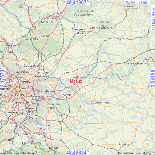
Meaux GPS coordinates[2]
48° 57' 36.504" North, 2° 52' 43.86" East
| Map corner | latitude | longitude |
|---|---|---|
| Upper-left | 49.41967°, | 2.17573° |
| Center: | 48.96014°, | 2.87885° |
| Lower-right: | 48.49634°, | 3.58198° |
| Map W x H: | 102.7×102.7 km | = 63.8×63.8mi |
| max Lat: | 51.07786° ⇑21.2% North |
| Meaux: | 48.96014° |
| min Lat: | ⇓78.8% South 41.3874° |
| min Long | Meaux | max Long |
| -5.08615° | 2.87885° | 9.52242° |
| W 56.1%⇐ | ⇒43.9% E |
Elevation
Elevation of Meaux is 61 m = 200 ft, and this is 132.7 m = 435 ft below average elevation for this country.
| Max E: |
2333 m = 7654 ft | 77.3% |
| Avg. | 193.7 m = 635 ft | |
| Meaux | 61 m = 200 ft | |
Min E: |
-1 m = -3 ft | 22.7% |
See also: Meaux elevation on elevation.city.
Geographical zone
Meaux is located in North temperate zone (between Tropic of Cancer and the Arctic Circle). Distance of this North polar circle is 1957.3 km =1216.2 mi to North.| Distance of | km | miles | from Meaux |
|---|---|---|---|
| North Pole | 4563.2 | 2835.4 | to North |
| Arctic Circle | 1957.3 | 1216.2 | to North |
| Tropic Cancer | 2837.9 | 1763.4 | to South |
| Equator | 5443.9 | 3382.7 | to South |


Nearby cities:
15 places around Meaux: (largest is in red/bold)
• Boutigny
5.8 km =3.6 mi,  139°
139°
• Chambry
4.4 km =2.7 mi,  14°
14°
• Chauconin-Neufmontiers
2.2 km =1.4 mi,  289°
289°
• Crégy-lès-Meaux
1.8 km =1.1 mi,  350°
350°
• Fublaines
4.9 km =3 mi,  120°
120°
• Isles-lès-Villenoy
6.5 km =4 mi,  215°
215°
• Mareuil-lès-Meaux
4 km =2.5 mi,  198°
198°
• Monthyon
6.5 km =4 mi,  323°
323°
• Nanteuil-lès-Meaux
3.6 km =2.2 mi,  159°
159°
• Penchard
3.2 km =2 mi,  335°
335°
• Poincy
4.3 km =2.7 mi,  75°
75°
• Trilbardou
5.7 km =3.5 mi,  249°
249°
• Trilport
5.3 km =3.3 mi,  93°
93°
• Varreddes
6 km =3.7 mi,  36°
36°
• Villenoy
2.5 km =1.6 mi,  212°
212°
Sources, notices
• [Note1] Compared only with cities in France existing in our database
• [Src1] Map data: © OpenStreetMap contributors (CC-BY-SA)
• [Src2] Other city data from geonames.org with taken over terms of usage.
• [Src3] Geographical zone / Annual Mean Temperature by Robert A. Rohde @ Wikipedia
