Bourdeaux geodata
Bourdeaux (Auvergne-Rhône-Alpes) is a populated place; located in France in Europe/Paris (GMT+2) time zone. With population of 601 people, there are 13304 cities with bigger population in this country. Compared to other cities in France, 82.9% of cities are located further ↑North; 79.1% of cities are located further ←West and 89.1% of cities have lower elevation than Bourdeaux. Note1
Administrative division(s):
- Level 1: Auvergne-Rhône-Alpes
- Level 2: Département de la Drôme
- Level 3: Arrondissement de Nyons
- Level 4: Bourdeaux


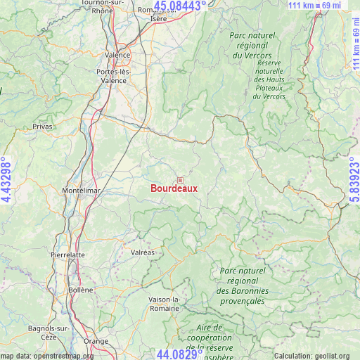
Bourdeaux GPS coordinates[2]
44° 35' 8.952" North, 5° 8' 9.996" East
| Map corner | latitude | longitude |
|---|---|---|
| Upper-left | 45.08443°, | 4.43298° |
| Center: | 44.58582°, | 5.13611° |
| Lower-right: | 44.0829°, | 5.83923° |
| Map W x H: | 111.4×111.4 km | = 69.2×69.2mi |
| max Lat: | 51.07786° ⇑82.9% North |
| Bourdeaux: | 44.58582° |
| min Lat: | ⇓17.1% South 41.3874° |
| min Long | Bourdeaux | max Long |
| -5.08615° | 5.13611° | 9.52242° |
| W 79.1%⇐ | ⇒20.9% E |
Elevation
Elevation of Bourdeaux is 409 m = 1342 ft, and this is 215.3 m = 706 ft above average elevation for this country.
| Max E: |
2333 m = 7654 ft | 10.9% |
| Bourdeaux | 409 m 1342 ft | |
| Avg. | 193.7 m = 635 ft | |
Min E: |
-1 m = -3 ft | 89.1% |
See also: France elevation on elevation.city.
Geographical zone
Bourdeaux is located in North temperate zone (between Tropic of Cancer and the Arctic Circle). Distance of this Northern Tropic circle is 2351.6 km =1461.2 mi to South.| Distance of | km | miles | from Bourdeaux |
|---|---|---|---|
| North Pole | 5049.6 | 3137.7 | to North |
| Arctic Circle | 2443.7 | 1518.4 | to North |
| Tropic Cancer | 2351.6 | 1461.2 | to South |
| Equator | 4957.5 | 3080.4 | to South |


Nearby cities:
15 places around Bourdeaux: (largest is in red/bold)
• Aouste-sur-Sye
16.1 km =10 mi,  336°
336°
• Charols
14.6 km =9.1 mi,  272°
272°
• Cléon-d’Andran
16.1 km =10 mi,  280°
280°
• Condorcet
20.5 km =12.7 mi,  165°
165°
• Crest
18.3 km =11.4 mi,  328°
328°
• Dieulefit
8.9 km =5.5 mi,  221°
221°
• Haut Divajeu
16.1 km =10 mi,  324°
324°
• La Bégude-de-Mazenc
16.7 km =10.4 mi,  253°
253°
• Le Poët-Laval
11.1 km =6.9 mi,  240°
240°
• Mirabel-et-Blacons
14.3 km =8.9 mi,  350°
350°
• Piégros-la-Clastre
11 km =6.8 mi, 344°
• Puy-Saint-Martin
13.8 km =8.6 mi,  290°
290°
• Saillans
12.7 km =7.9 mi,  16°
16°
• Saint-Gervais-sur-Roubion
19.7 km =12.2 mi, 268°
• Saou
8.8 km =5.5 mi, 319°
Sources, notices
• [Note1] Compared only with cities in France existing in our database
• [Src1] Map data: © OpenStreetMap contributors (CC-BY-SA)
• [Src2] Other city data from geonames.org with taken over terms of usage.
• [Src3] Geographical zone / Annual Mean Temperature by Robert A. Rohde @ Wikipedia
