Dieulefit geodata
Dieulefit (Auvergne-Rhône-Alpes) is a populated place; located in France in Europe/Paris (GMT+2) time zone. With population of 3,214 people, there are 3034 cities with bigger population in this country. Compared to other cities in France, 83.4% of cities are located further ↑North; 78.3% of cities are located further ←West and 90.1% of cities have lower elevation than Dieulefit. Note1
Administrative division(s):
- Level 1: Auvergne-Rhône-Alpes
- Level 2: Département de la Drôme
- Level 3: Arrondissement de Nyons
- Level 4: Dieulefit


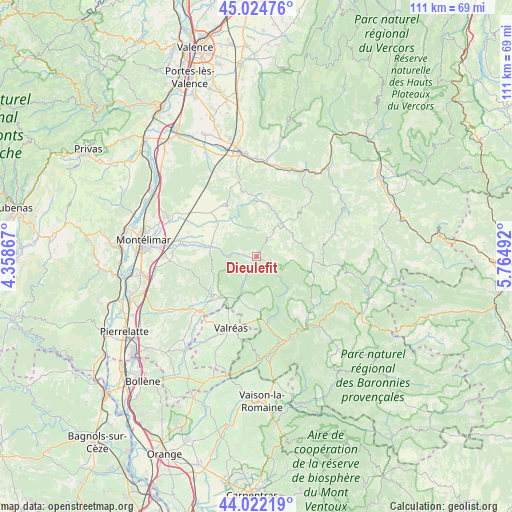
Dieulefit GPS coordinates[2]
44° 31' 32.268" North, 5° 3' 42.48" East
| Map corner | latitude | longitude |
|---|---|---|
| Upper-left | 45.02476°, | 4.35867° |
| Center: | 44.52563°, | 5.0618° |
| Lower-right: | 44.02219°, | 5.76492° |
| Map W x H: | 111.5×111.5 km | = 69.3×69.3mi |
| max Lat: | 51.07786° ⇑83.4% North |
| Dieulefit: | 44.52563° |
| min Lat: | ⇓16.6% South 41.3874° |
| min Long | Dieulefit | max Long |
| -5.08615° | 5.0618° | 9.52242° |
| W 78.3%⇐ | ⇒21.7% E |
Elevation
Elevation of Dieulefit is 428 m = 1404 ft, and this is 234.3 m = 769 ft above average elevation for this country.
| Max E: |
2333 m = 7654 ft | 9.9% |
| Dieulefit | 428 m 1404 ft | |
| Avg. | 193.7 m = 635 ft | |
Min E: |
-1 m = -3 ft | 90.1% |
See also: France elevation on elevation.city.
Geographical zone
Dieulefit is located in North temperate zone (between Tropic of Cancer and the Arctic Circle). Distance of this Northern Tropic circle is 2344.9 km =1457.1 mi to South.| Distance of | km | miles | from Dieulefit |
|---|---|---|---|
| North Pole | 5056.3 | 3141.8 | to North |
| Arctic Circle | 2450.4 | 1522.6 | to North |
| Tropic Cancer | 2344.9 | 1457.1 | to South |
| Equator | 4950.8 | 3076.3 | to South |


Nearby cities:
15 places around Dieulefit: (largest is in red/bold)
• Bourdeaux
8.9 km =5.5 mi,  41°
41°
• Charols
11.3 km =7 mi,  309°
309°
• Cléon-d’Andran
13.8 km =8.6 mi, 313°
• Condorcet
17.1 km =10.6 mi,  140°
140°
• Grignan
17 km =10.6 mi,  226°
226°
• La Bâtie-Rolland
15.9 km =9.9 mi,  281°
281°
• La Bégude-de-Mazenc
10.3 km =6.4 mi, 280°
• Le Poët-Laval
3.9 km =2.4 mi,  288°
288°
• Piégros-la-Clastre
17.5 km =10.9 mi,  9°
9°
• Puy-Saint-Martin
13.5 km =8.4 mi,  328°
328°
• Saint-Gervais-sur-Roubion
15.1 km =9.4 mi, 294°
• Saou
13.4 km =8.3 mi,  0°
0°
• Taulignan
11.6 km =7.2 mi,  218°
218°
• Valréas
16.6 km =10.3 mi,  199°
199°
• Venterol
15.5 km =9.6 mi,  168°
168°
Sources, notices
• [Note1] Compared only with cities in France existing in our database
• [Src1] Map data: © OpenStreetMap contributors (CC-BY-SA)
• [Src2] Other city data from geonames.org with taken over terms of usage.
• [Src3] Geographical zone / Annual Mean Temperature by Robert A. Rohde @ Wikipedia
