Bouquetot geodata
Bouquetot (Normandy) is a populated place; located in France in Europe/Paris (GMT+2) time zone. With population of 883 people, there are 9798 cities with bigger population in this country. Compared to other cities in France, 87.3% of cities are located further ↓South; 70.7% of cities are located further →East and 50.6% of cities have lower elevation than Bouquetot. Note1
Administrative division(s):
- Level 1: Normandy
- Level 2: Département de l'Eure
- Level 3: Arrondissement de Bernay
- Level 4: Bouquetot


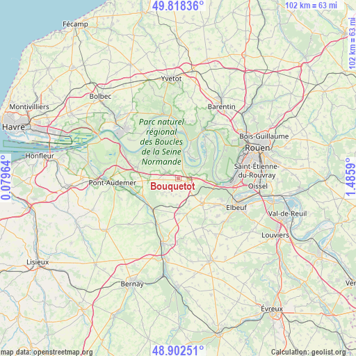
Bouquetot GPS coordinates[2]
49° 21' 45.252" North, 0° 46' 57.972" East
| Map corner | latitude | longitude |
|---|---|---|
| Upper-left | 49.81836°, | 0.07964° |
| Center: | 49.36257°, | 0.78277° |
| Lower-right: | 48.90251°, | 1.4859° |
| Map W x H: | 101.8×101.8 km | = 63.3×63.3mi |
| max Lat: | 51.07786° ⇑12.7% North |
| Bouquetot: | 49.36257° |
| min Lat: | ⇓87.3% South 41.3874° |
| min Long | Bouquetot | max Long |
| -5.08615° | 0.78277° | 9.52242° |
| W 29.3%⇐ | ⇒70.7% E |
Elevation
Elevation of Bouquetot is 134 m = 440 ft, and this is 59.7 m = 196 ft below average elevation for this country.
| Max E: |
2333 m = 7654 ft | 49.4% |
| Avg. | 193.7 m = 635 ft | |
| Bouquetot | 134 m = 440 ft | |
Min E: |
-1 m = -3 ft | 50.6% |
See also: France elevation on elevation.city.
Geographical zone
Bouquetot is located in North temperate zone (between Tropic of Cancer and the Arctic Circle). Distance of this North polar circle is 1912.6 km =1188.4 mi to North.| Distance of | km | miles | from Bouquetot |
|---|---|---|---|
| North Pole | 4518.5 | 2807.7 | to North |
| Arctic Circle | 1912.6 | 1188.4 | to North |
| Tropic Cancer | 2882.7 | 1791.2 | to South |
| Equator | 5488.6 | 3410.5 | to South |


Nearby cities:
15 places around Bouquetot: (largest is in red/bold)
• Berville-en-Roumois
8 km =5 mi,  158°
158°
• Boissey-le-Châtel
10.2 km =6.3 mi,  179°
179°
• Bosgouet
5.4 km =3.4 mi,  100°
100°
• Bourg-Achard
2.6 km =1.6 mi,  113°
113°
• Bourgtheroulde-Infreville
10.1 km =6.3 mi,  133°
133°
• Caumont
8.2 km =5.1 mi,  87°
87°
• Hauville
3.8 km =2.4 mi,  348°
348°
• Honguemare-Guenouville
2.2 km =1.4 mi,  67°
67°
• Illeville-sur-Montfort
5.8 km =3.6 mi,  225°
225°
• Jumièges
8.3 km =5.2 mi,  18°
18°
• Le Mesnil-sous-Jumièges
7.8 km =4.8 mi,  45°
45°
• Routot
4 km =2.5 mi,  295°
295°
• Saint-Ouen-de-Thouberville
7.7 km =4.8 mi, 94°
• Yainville
10.7 km =6.6 mi, 18°
• Étréville
9.8 km =6.1 mi,  276°
276°
Sources, notices
• [Note1] Compared only with cities in France existing in our database
• [Src1] Map data: © OpenStreetMap contributors (CC-BY-SA)
• [Src2] Other city data from geonames.org with taken over terms of usage.
• [Src3] Geographical zone / Annual Mean Temperature by Robert A. Rohde @ Wikipedia
