Bosgouet geodata
Bosgouet (Normandy) is a populated place; located in France in Europe/Paris (GMT+2) time zone. With population of 580 people, there are 13652 cities with bigger population in this country. Compared to other cities in France, 87.1% of cities are located further ↓South; 70.1% of cities are located further →East and 51.7% of cities have higher elevation than Bosgouet. Note1
Administrative division(s):
- Level 1: Normandy
- Level 2: Département de l'Eure
- Level 3: Arrondissement de Bernay
- Level 4: Bosgouet


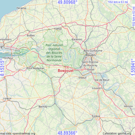
Bosgouet GPS coordinates[2]
49° 21' 13.68" North, 0° 51' 22.608" East
| Map corner | latitude | longitude |
|---|---|---|
| Upper-left | 49.80968°, | 0.15315° |
| Center: | 49.3538°, | 0.85628° |
| Lower-right: | 48.89366°, | 1.55941° |
| Map W x H: | 101.9×101.9 km | = 63.3×63.3mi |
| max Lat: | 51.07786° ⇑12.9% North |
| Bosgouet: | 49.3538° |
| min Lat: | ⇓87.1% South 41.3874° |
| min Long | Bosgouet | max Long |
| -5.08615° | 0.85628° | 9.52242° |
| W 29.9%⇐ | ⇒70.1% E |
Elevation
Elevation of Bosgouet is 126 m = 413 ft, and this is 67.7 m = 222 ft below average elevation for this country.
| Max E: |
2333 m = 7654 ft | 51.7% |
| Avg. | 193.7 m = 635 ft | |
| Bosgouet | 126 m = 413 ft | |
Min E: |
-1 m = -3 ft | 48.3% |
See also: France elevation on elevation.city.
Geographical zone
Bosgouet is located in North temperate zone (between Tropic of Cancer and the Arctic Circle). Distance of this North polar circle is 1913.5 km =1189 mi to North.| Distance of | km | miles | from Bosgouet |
|---|---|---|---|
| North Pole | 4519.4 | 2808.2 | to North |
| Arctic Circle | 1913.5 | 1189 | to North |
| Tropic Cancer | 2881.7 | 1790.6 | to South |
| Equator | 5487.6 | 3409.8 | to South |


Nearby cities:
15 places around Bosgouet: (largest is in red/bold)
• Berville-en-Roumois
6.9 km =4.3 mi,  200°
200°
• Bouquetot
5.4 km =3.4 mi,  280°
280°
• Bourg-Achard
2.9 km =1.8 mi,  268°
268°
• Bourgtheroulde-Infreville
6.3 km =3.9 mi,  161°
161°
• Caumont
3.2 km =2 mi,  63°
63°
• Hauville
7.7 km =4.8 mi,  307°
307°
• Honguemare-Guenouville
3.8 km =2.4 mi,  299°
299°
• Jumièges
9.2 km =5.7 mi,  343°
343°
• La Bouille
5.6 km =3.5 mi,  94°
94°
• Le Mesnil-sous-Jumièges
6.4 km =4 mi,  2°
2°
• Moulineaux
7.5 km =4.7 mi,  99°
99°
• Sahurs
6.3 km =3.9 mi, 85°
• Saint-Ouen-de-Thouberville
2.4 km =1.5 mi,  80°
80°
• Saint-Ouen-du-Tilleul
9.1 km =5.7 mi,  133°
133°
• Saint-Pierre-de-Manneville
7.1 km =4.4 mi,  52°
52°
Sources, notices
• [Note1] Compared only with cities in France existing in our database
• [Src1] Map data: © OpenStreetMap contributors (CC-BY-SA)
• [Src2] Other city data from geonames.org with taken over terms of usage.
• [Src3] Geographical zone / Annual Mean Temperature by Robert A. Rohde @ Wikipedia
