Caumont geodata
Caumont (Normandy) is a populated place; located in France in Europe/Paris (GMT+2) time zone. With population of 1,043 people, there are 8513 cities with bigger population in this country. Compared to other cities in France, 87.3% of cities are located further ↓South; 69.8% of cities are located further →East and 51.2% of cities have higher elevation than Caumont. Note1
Administrative division(s):
- Level 1: Normandy
- Level 2: Département de l'Eure
- Level 3: Arrondissement de Bernay
- Level 4: Caumont


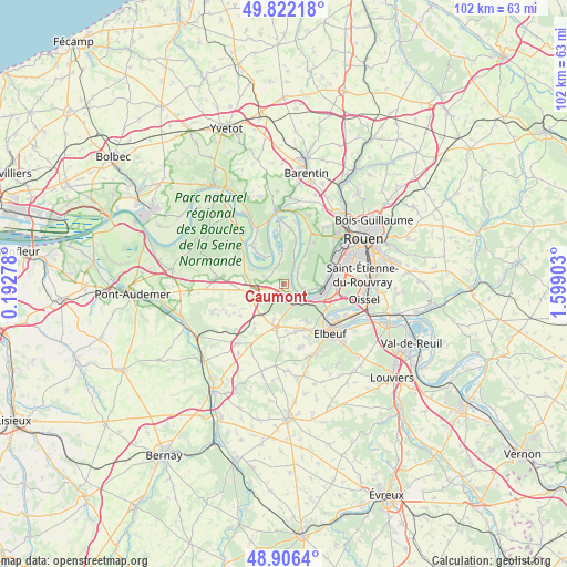
Caumont GPS coordinates[2]
49° 21' 59.112" North, 0° 53' 45.276" East
| Map corner | latitude | longitude |
|---|---|---|
| Upper-left | 49.82218°, | 0.19278° |
| Center: | 49.36642°, | 0.89591° |
| Lower-right: | 48.9064°, | 1.59903° |
| Map W x H: | 101.8×101.8 km | = 63.3×63.3mi |
| max Lat: | 51.07786° ⇑12.7% North |
| Caumont: | 49.36642° |
| min Lat: | ⇓87.3% South 41.3874° |
| min Long | Caumont | max Long |
| -5.08615° | 0.89591° | 9.52242° |
| W 30.2%⇐ | ⇒69.8% E |
Elevation
Elevation of Caumont is 128 m = 420 ft, and this is 65.7 m = 216 ft below average elevation for this country.
| Max E: |
2333 m = 7654 ft | 51.2% |
| Avg. | 193.7 m = 635 ft | |
| Caumont | 128 m = 420 ft | |
Min E: |
-1 m = -3 ft | 48.8% |
See also: France elevation on elevation.city.
Geographical zone
Caumont is located in North temperate zone (between Tropic of Cancer and the Arctic Circle). Distance of this North polar circle is 1912.1 km =1188.1 mi to North.| Distance of | km | miles | from Caumont |
|---|---|---|---|
| North Pole | 4518 | 2807.4 | to North |
| Arctic Circle | 1912.1 | 1188.1 | to North |
| Tropic Cancer | 2883.1 | 1791.5 | to South |
| Equator | 5489 | 3410.7 | to South |


Nearby cities:
15 places around Caumont: (largest is in red/bold)
• Bardouville
7.9 km =4.9 mi,  16°
16°
• Bosgouet
3.2 km =2 mi,  243°
243°
• Bouquetot
8.2 km =5.1 mi,  267°
267°
• Bourg-Achard
6 km =3.7 mi,  255°
255°
• Bourgtheroulde-Infreville
7.4 km =4.6 mi,  187°
187°
• Grand-Couronne
8.1 km =5 mi,  98°
98°
• Honguemare-Guenouville
6.2 km =3.9 mi, 274°
• La Bouille
3.3 km =2.1 mi,  123°
123°
• Le Mesnil-sous-Jumièges
5.6 km =3.5 mi,  332°
332°
• Moulineaux
5.2 km =3.2 mi, 119°
• Quevillon
7.2 km =4.5 mi,  35°
35°
• Sahurs
3.5 km =2.2 mi, 104°
• Saint-Ouen-de-Thouberville
1.2 km =0.7 mi,  207°
207°
• Saint-Pierre-de-Manneville
4 km =2.5 mi, 42°
• Val-de-la-Haye
7.8 km =4.8 mi,  79°
79°
Sources, notices
• [Note1] Compared only with cities in France existing in our database
• [Src1] Map data: © OpenStreetMap contributors (CC-BY-SA)
• [Src2] Other city data from geonames.org with taken over terms of usage.
• [Src3] Geographical zone / Annual Mean Temperature by Robert A. Rohde @ Wikipedia
