Bossey geodata
Bossey (Auvergne-Rhône-Alpes) is a populated place; located in France in Europe/Paris (GMT+2) time zone. With population of 606 people, there are 13224 cities with bigger population in this country. Compared to other cities in France, 64.3% of cities are located further ↑North; 88.9% of cities are located further ←West and 94.4% of cities have lower elevation than Bossey. Note1
Administrative division(s):
- Level 1: Auvergne-Rhône-Alpes
- Level 2: Haute-Savoie
- Level 3: Arrondissement de Saint-Julien-en-Genevois
- Level 4: Bossey


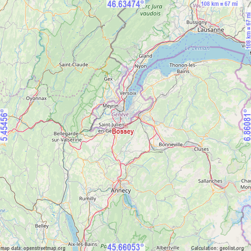
Bossey GPS coordinates[2]
46° 8' 59.244" North, 6° 9' 27.684" East
| Map corner | latitude | longitude |
|---|---|---|
| Upper-left | 46.63474°, | 5.45456° |
| Center: | 46.14979°, | 6.15769° |
| Lower-right: | 45.66053°, | 6.86081° |
| Map W x H: | 108.3×108.3 km | = 67.3×67.3mi |
| max Lat: | 51.07786° ⇑64.3% North |
| Bossey: | 46.14979° |
| min Lat: | ⇓35.7% South 41.3874° |
| min Long | Bossey | max Long |
| -5.08615° | 6.15769° | 9.52242° |
| W 88.9%⇐ | ⇒11.1% E |
Elevation
Elevation of Bossey is 559 m = 1834 ft, and this is 365.3 m = 1198 ft above average elevation for this country.
| Max E: |
2333 m = 7654 ft | 5.6% |
| Bossey | 559 m 1834 ft | |
| Avg. | 193.7 m = 635 ft | |
Min E: |
-1 m = -3 ft | 94.4% |
See also: France elevation on elevation.city.
Geographical zone
Bossey is located in North temperate zone (between Tropic of Cancer and the Arctic Circle). Distance of this North polar circle is 2269.8 km =1410.4 mi to North.| Distance of | km | miles | from Bossey |
|---|---|---|---|
| North Pole | 4875.7 | 3029.6 | to North |
| Arctic Circle | 2269.8 | 1410.4 | to North |
| Tropic Cancer | 2525.5 | 1569.3 | to South |
| Equator | 5131.4 | 3188.5 | to South |


Nearby cities:
15 places around Bossey: (largest is in red/bold)
• Annemasse
7.9 km =4.9 mi,  51°
51°
• Arbusigny
7.9 km =4.9 mi,  143°
143°
• Archamps
3.2 km =2 mi,  231°
231°
• Arthaz-Pont-Notre-Dame
8.4 km =5.2 mi,  82°
82°
• Beaumont
5.8 km =3.6 mi,  209°
209°
• Collonges-sous-Salève
1 km =0.6 mi,  198°
198°
• Feigères
7.3 km =4.5 mi,  235°
235°
• Gaillard
5.5 km =3.4 mi,  43°
43°
• La Muraz
4.6 km =2.9 mi,  129°
129°
• Monnetier-Mornex
3.9 km =2.4 mi,  72°
72°
• Neydens
5.2 km =3.2 mi, 232°
• Reignier-Ésery
8.6 km =5.3 mi,  102°
102°
• Saint-Julien-en-Genevois
5.8 km =3.6 mi,  264°
264°
• Vétraz-Monthoux
8.2 km =5.1 mi, 70°
• Étrembières
6.3 km =3.9 mi,  58°
58°
Sources, notices
• [Note1] Compared only with cities in France existing in our database
• [Src1] Map data: © OpenStreetMap contributors (CC-BY-SA)
• [Src2] Other city data from geonames.org with taken over terms of usage.
• [Src3] Geographical zone / Annual Mean Temperature by Robert A. Rohde @ Wikipedia
