Beaumont geodata
Beaumont (Auvergne-Rhône-Alpes) is a populated place; located in France in Europe/Paris (GMT+2) time zone. With population of 1,432 people, there are 6472 cities with bigger population in this country. Compared to other cities in France, 65% of cities are located further ↑North; 88.4% of cities are located further ←West and 98.1% of cities have lower elevation than Beaumont. Note1
Administrative division(s):
- Level 1: Auvergne-Rhône-Alpes
- Level 2: Haute-Savoie
- Level 3: Arrondissement de Saint-Julien-en-Genevois
- Level 4: Beaumont


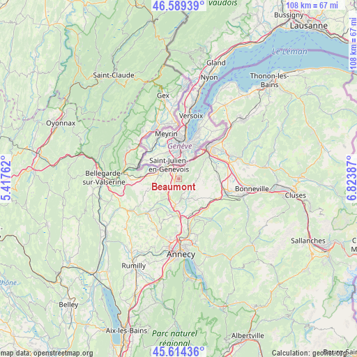
Beaumont GPS coordinates[2]
46° 6' 14.508" North, 6° 7' 14.664" East
| Map corner | latitude | longitude |
|---|---|---|
| Upper-left | 46.58939°, | 5.41762° |
| Center: | 46.10403°, | 6.12074° |
| Lower-right: | 45.61436°, | 6.82387° |
| Map W x H: | 108.4×108.4 km | = 67.4×67.4mi |
| max Lat: | 51.07786° ⇑65% North |
| Beaumont: | 46.10403° |
| min Lat: | ⇓35% South 41.3874° |
| min Long | Beaumont | max Long |
| -5.08615° | 6.12074° | 9.52242° |
| W 88.4%⇐ | ⇒11.6% E |
Elevation
Elevation of Beaumont is 837 m = 2746 ft, and this is 643.3 m = 2111 ft above average elevation for this country.
| Max E: |
2333 m = 7654 ft | 1.9% |
| Beaumont | 837 m 2746 ft | |
| Avg. | 193.7 m = 635 ft | |
Min E: |
-1 m = -3 ft | 98.1% |
See also: France elevation on elevation.city.
Geographical zone
Beaumont is located in North temperate zone (between Tropic of Cancer and the Arctic Circle). Distance of this North polar circle is 2274.9 km =1413.6 mi to North.| Distance of | km | miles | from Beaumont |
|---|---|---|---|
| North Pole | 4880.8 | 3032.8 | to North |
| Arctic Circle | 2274.9 | 1413.6 | to North |
| Tropic Cancer | 2520.4 | 1566.1 | to South |
| Equator | 5126.3 | 3185.3 | to South |


Nearby cities:
15 places around Beaumont: (largest is in red/bold)
• Andilly
6.6 km =4.1 mi,  220°
220°
• Arbusigny
7.6 km =4.7 mi,  99°
99°
• Archamps
3.1 km =1.9 mi,  6°
6°
• Bossey
5.8 km =3.6 mi,  29°
29°
• Cernex
7.2 km =4.5 mi,  230°
230°
• Collonges-sous-Salève
4.9 km =3 mi, 31°
• Copponex
7 km =4.3 mi,  211°
211°
• Feigères
3.3 km =2.1 mi,  286°
286°
• La Muraz
6.7 km =4.2 mi,  71°
71°
• Menthonnex-en-Bornes
7 km =4.3 mi,  145°
145°
• Neydens
2.3 km =1.4 mi,  327°
327°
• Présilly
3.5 km =2.2 mi,  248°
248°
• Saint-Julien-en-Genevois
5.4 km =3.4 mi, 326°
• Vers
7.1 km =4.4 mi,  256°
256°
• Viry
6.4 km =4 mi,  278°
278°
Sources, notices
• [Note1] Compared only with cities in France existing in our database
• [Src1] Map data: © OpenStreetMap contributors (CC-BY-SA)
• [Src2] Other city data from geonames.org with taken over terms of usage.
• [Src3] Geographical zone / Annual Mean Temperature by Robert A. Rohde @ Wikipedia
