Bordes geodata
Bordes (Occitanie) is a populated place; located in France in Europe/Paris (GMT+2) time zone. With population of 607 people, there are 13209 cities with bigger population in this country. Compared to other cities in France, 97.1% of cities are located further ↑North; 76% of cities are located further →East and 77.4% of cities have lower elevation than Bordes. Note1
Administrative division(s):
- Level 1: Occitanie
- Level 2: Département des Hautes-Pyrénées
- Level 3: Arrondissement de Tarbes
- Level 4: Bordes


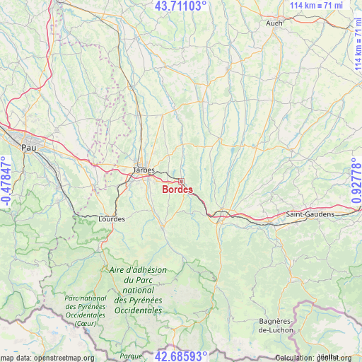
Bordes GPS coordinates[2]
43° 12' 2.268" North, 0° 13' 28.74" East
| Map corner | latitude | longitude |
|---|---|---|
| Upper-left | 43.71103°, | -0.47847° |
| Center: | 43.20063°, | 0.22465° |
| Lower-right: | 42.68593°, | 0.92778° |
| Map W x H: | 114×114 km | = 70.8×70.8mi |
| max Lat: | 51.07786° ⇑97.1% North |
| Bordes: | 43.20063° |
| min Lat: | ⇓2.9% South 41.3874° |
| min Long | Bordes | max Long |
| -5.08615° | 0.22465° | 9.52242° |
| W 24%⇐ | ⇒76% E |
Elevation
Elevation of Bordes is 267 m = 876 ft, and this is 73.3 m = 240 ft above average elevation for this country.
| Max E: |
2333 m = 7654 ft | 22.6% |
| Bordes | 267 m 876 ft | |
| Avg. | 193.7 m = 635 ft | |
Min E: |
-1 m = -3 ft | 77.4% |
See also: France elevation on elevation.city.
Geographical zone
Bordes is located in North temperate zone (between Tropic of Cancer and the Arctic Circle). Distance of this Northern Tropic circle is 2197.5 km =1365.5 mi to South.| Distance of | km | miles | from Bordes |
|---|---|---|---|
| North Pole | 5203.6 | 3233.4 | to North |
| Arctic Circle | 2597.7 | 1614.1 | to North |
| Tropic Cancer | 2197.5 | 1365.5 | to South |
| Equator | 4803.5 | 2984.8 | to South |


Nearby cities:
15 places around Bordes: (largest is in red/bold)
• Aureilhan
11.5 km =7.1 mi,  294°
294°
• Barbazan-Debat
8.5 km =5.3 mi,  266°
266°
• Bernac-Debat
10.2 km =6.3 mi,  248°
248°
• Cieutat
8.6 km =5.3 mi,  184°
184°
• Horgues
11.2 km =7 mi,  263°
263°
• Laloubère
12.3 km =7.6 mi, 271°
• Momères
11.2 km =7 mi, 256°
• Montgaillard
12.7 km =7.9 mi,  228°
228°
• Orleix
12.2 km =7.6 mi,  315°
315°
• Pouyastruc
8.7 km =5.4 mi,  327°
327°
• Sarrouilles
8.5 km =5.3 mi, 292°
• Soues
10.2 km =6.3 mi, 274°
• Séméac
10.1 km =6.3 mi, 288°
• Tarbes
12 km =7.5 mi, 287°
• Tournay
2.4 km =1.5 mi,  138°
138°
Sources, notices
• [Note1] Compared only with cities in France existing in our database
• [Src1] Map data: © OpenStreetMap contributors (CC-BY-SA)
• [Src2] Other city data from geonames.org with taken over terms of usage.
• [Src3] Geographical zone / Annual Mean Temperature by Robert A. Rohde @ Wikipedia
