Cieutat geodata
Cieutat (Occitanie) is a populated place; located in France in Europe/Paris (GMT+2) time zone. With population of 544 people, there are 14318 cities with bigger population in this country. Compared to other cities in France, 97.8% of cities are located further ↑North; 76.1% of cities are located further →East and 94% of cities have lower elevation than Cieutat. Note1
Administrative division(s):
- Level 1: Occitanie
- Level 2: Département des Hautes-Pyrénées
- Level 3: Arrondissement de Bagnères-de-Bigorre
- Level 4: Cieutat


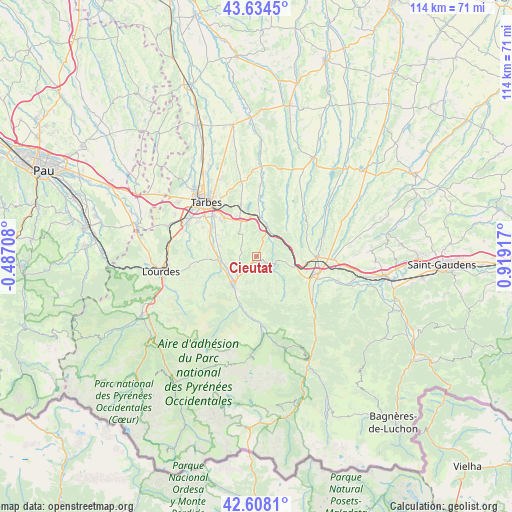
Cieutat GPS coordinates[2]
43° 7' 24.42" North, 0° 12' 57.744" East
| Map corner | latitude | longitude |
|---|---|---|
| Upper-left | 43.6345°, | -0.48708° |
| Center: | 43.12345°, | 0.21604° |
| Lower-right: | 42.6081°, | 0.91917° |
| Map W x H: | 114.1×114.1 km | = 70.9×70.9mi |
| max Lat: | 51.07786° ⇑97.8% North |
| Cieutat: | 43.12345° |
| min Lat: | ⇓2.2% South 41.3874° |
| min Long | Cieutat | max Long |
| -5.08615° | 0.21604° | 9.52242° |
| W 23.9%⇐ | ⇒76.1% E |
Elevation
Elevation of Cieutat is 542 m = 1778 ft, and this is 348.3 m = 1143 ft above average elevation for this country.
| Max E: |
2333 m = 7654 ft | 6% |
| Cieutat | 542 m 1778 ft | |
| Avg. | 193.7 m = 635 ft | |
Min E: |
-1 m = -3 ft | 94% |
See also: France elevation on elevation.city.
Geographical zone
Cieutat is located in North temperate zone (between Tropic of Cancer and the Arctic Circle). Distance of this Northern Tropic circle is 2189 km =1360.2 mi to South.| Distance of | km | miles | from Cieutat |
|---|---|---|---|
| North Pole | 5212.2 | 3238.7 | to North |
| Arctic Circle | 2606.3 | 1619.5 | to North |
| Tropic Cancer | 2189 | 1360.2 | to South |
| Equator | 4794.9 | 2979.4 | to South |


Nearby cities:
15 places around Cieutat: (largest is in red/bold)
• Asté
9.9 km =6.2 mi,  202°
202°
• Avezac-Prat-Lahitte
11.4 km =7.1 mi,  123°
123°
• Bagnères-de-Bigorre
8.5 km =5.3 mi,  219°
219°
• Barbazan-Debat
11.2 km =7 mi,  316°
316°
• Bernac-Debat
10.1 km =6.3 mi,  299°
299°
• Bordes
8.6 km =5.3 mi,  4°
4°
• Campan
12.3 km =7.6 mi,  194°
194°
• Capvern
8.4 km =5.2 mi,  105°
105°
• Gerde
8.5 km =5.3 mi,  207°
207°
• Horgues
12.7 km =7.9 mi, 304°
• Momères
11.9 km =7.4 mi, 300°
• Montgaillard
8.8 km =5.5 mi,  271°
271°
• Pouzac
7.8 km =4.8 mi,  237°
237°
• Tournay
7.2 km =4.5 mi,  18°
18°
• Trébons
8.1 km =5 mi,  252°
252°
Sources, notices
• [Note1] Compared only with cities in France existing in our database
• [Src1] Map data: © OpenStreetMap contributors (CC-BY-SA)
• [Src2] Other city data from geonames.org with taken over terms of usage.
• [Src3] Geographical zone / Annual Mean Temperature by Robert A. Rohde @ Wikipedia
