Pouyastruc geodata
Pouyastruc (Occitanie) is a populated place; located in France in Europe/Paris (GMT+2) time zone. With population of 569 people, there are 13839 cities with bigger population in this country. Compared to other cities in France, 96.4% of cities are located further ↑North; 76.6% of cities are located further →East and 83.9% of cities have lower elevation than Pouyastruc. Note1
Administrative division(s):
- Level 1: Occitanie
- Level 2: Département des Hautes-Pyrénées
- Level 3: Arrondissement de Tarbes
- Level 4: Pouyastruc


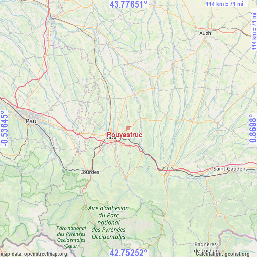
Pouyastruc GPS coordinates[2]
43° 16' 0.012" North, 0° 10' 0.012" East
| Map corner | latitude | longitude |
|---|---|---|
| Upper-left | 43.77651°, | -0.53645° |
| Center: | 43.26667°, | 0.16667° |
| Lower-right: | 42.75252°, | 0.8698° |
| Map W x H: | 113.9×113.9 km | = 70.8×70.8mi |
| max Lat: | 51.07786° ⇑96.4% North |
| Pouyastruc: | 43.26667° |
| min Lat: | ⇓3.6% South 41.3874° |
| min Long | Pouyastruc | max Long |
| -5.08615° | 0.16667° | 9.52242° |
| W 23.4%⇐ | ⇒76.6% E |
Elevation
Elevation of Pouyastruc is 333 m = 1093 ft, and this is 139.3 m = 457 ft above average elevation for this country.
| Max E: |
2333 m = 7654 ft | 16.1% |
| Pouyastruc | 333 m 1093 ft | |
| Avg. | 193.7 m = 635 ft | |
Min E: |
-1 m = -3 ft | 83.9% |
See also: France elevation on elevation.city.
Geographical zone
Pouyastruc is located in North temperate zone (between Tropic of Cancer and the Arctic Circle). Distance of this Northern Tropic circle is 2204.9 km =1370.1 mi to South.| Distance of | km | miles | from Pouyastruc |
|---|---|---|---|
| North Pole | 5196.3 | 3228.8 | to North |
| Arctic Circle | 2590.4 | 1609.6 | to North |
| Tropic Cancer | 2204.9 | 1370.1 | to South |
| Equator | 4810.8 | 2989.3 | to South |


Nearby cities:
15 places around Pouyastruc: (largest is in red/bold)
• Andrest
10.2 km =6.3 mi,  305°
305°
• Aureilhan
6.3 km =3.9 mi,  245°
245°
• Aurensan
7.8 km =4.8 mi,  303°
303°
• Barbazan-Debat
8.7 km =5.4 mi,  205°
205°
• Bazet
8.5 km =5.3 mi,  288°
288°
• Bordes
8.7 km =5.4 mi,  147°
147°
• Bours
6.3 km =3.9 mi,  280°
280°
• Horgues
10.8 km =6.7 mi,  216°
216°
• Laloubère
10.3 km =6.4 mi,  227°
227°
• Orleix
4 km =2.5 mi, 290°
• Oursbelille
10.9 km =6.8 mi, 280°
• Sarrouilles
5.2 km =3.2 mi, 217°
• Soues
8.6 km =5.3 mi, 219°
• Séméac
6.4 km =4 mi, 229°
• Tarbes
7.7 km =4.8 mi,  241°
241°
Sources, notices
• [Note1] Compared only with cities in France existing in our database
• [Src1] Map data: © OpenStreetMap contributors (CC-BY-SA)
• [Src2] Other city data from geonames.org with taken over terms of usage.
• [Src3] Geographical zone / Annual Mean Temperature by Robert A. Rohde @ Wikipedia
