Bonny-sur-Loire geodata
Bonny-sur-Loire (Centre) is a populated place; located in France in Europe/Paris (GMT+2) time zone. With population of 2,025 people, there are 4728 cities with bigger population in this country. Compared to other cities in France, 52.1% of cities are located further ↓South; 55.6% of cities are located further ←West and 51.9% of cities have lower elevation than Bonny-sur-Loire. Note1
Administrative division(s):
- Level 1: Centre
- Level 2: Loiret
- Level 3: Arrondissement de Montargis
- Level 4: Bonny-sur-Loire


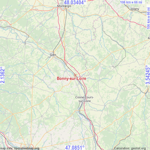
Bonny-sur-Loire GPS coordinates[2]
47° 33' 42.192" North, 2° 50' 21.588" East
| Map corner | latitude | longitude |
|---|---|---|
| Upper-left | 48.03404°, | 2.1362° |
| Center: | 47.56172°, | 2.83933° |
| Lower-right: | 47.0851°, | 3.54245° |
| Map W x H: | 105.5×105.5 km | = 65.6×65.6mi |
| max Lat: | 51.07786° ⇑47.9% North |
| Bonny-sur-Loire: | 47.56172° |
| min Lat: | ⇓52.1% South 41.3874° |
| min Long | Bonny-sur-Loire | max Long |
| -5.08615° | 2.83933° | 9.52242° |
| W 55.6%⇐ | ⇒44.4% E |
Elevation
Elevation of Bonny-sur-Loire is 139 m = 456 ft, and this is 54.7 m = 179 ft below average elevation for this country.
| Max E: |
2333 m = 7654 ft | 48.1% |
| Avg. | 193.7 m = 635 ft | |
| Bonny-sur-Loire | 139 m = 456 ft | |
Min E: |
-1 m = -3 ft | 51.9% |
See also: France elevation on elevation.city.
Geographical zone
Bonny-sur-Loire is located in North temperate zone (between Tropic of Cancer and the Arctic Circle). Distance of this North polar circle is 2112.8 km =1312.8 mi to North.| Distance of | km | miles | from Bonny-sur-Loire |
|---|---|---|---|
| North Pole | 4718.7 | 2932.1 | to North |
| Arctic Circle | 2112.8 | 1312.8 | to North |
| Tropic Cancer | 2682.4 | 1666.8 | to South |
| Equator | 5288.4 | 3286.1 | to South |


Nearby cities:
15 places around Bonny-sur-Loire: (largest is in red/bold)
• Arquian
11.4 km =7.1 mi,  101°
101°
• Belleville-sur-Loire
6.9 km =4.3 mi,  173°
173°
• Boulleret
15.5 km =9.6 mi, 170°
• Briare
10.7 km =6.6 mi,  318°
318°
• La Celle-sur-Loire
12 km =7.5 mi,  145°
145°
• Léré
10.6 km =6.6 mi, 167°
• Myennes
14.7 km =9.1 mi, 151°
• Neuvy-sur-Loire
5.4 km =3.4 mi,  142°
142°
• Ousson-sur-Loire
5 km =3.1 mi,  309°
309°
• Ouzouer-sur-Trézée
12.6 km =7.8 mi,  349°
349°
• Saint-Brisson-sur-Loire
15.1 km =9.4 mi, 308°
• Saint-Firmin-sur-Loire
10.7 km =6.6 mi, 311°
• Saint-Martin-sur-Ocre
17.4 km =10.8 mi, 308°
• Savigny-en-Sancerre
13.6 km =8.5 mi,  189°
189°
• Sury-près-Léré
8.8 km =5.5 mi, 166°
Sources, notices
• [Note1] Compared only with cities in France existing in our database
• [Src1] Map data: © OpenStreetMap contributors (CC-BY-SA)
• [Src2] Other city data from geonames.org with taken over terms of usage.
• [Src3] Geographical zone / Annual Mean Temperature by Robert A. Rohde @ Wikipedia
