Belleville-sur-Loire geodata
Belleville-sur-Loire (Centre) is a populated place; located in France in Europe/Paris (GMT+2) time zone. With population of 1,094 people, there are 8167 cities with bigger population in this country. Compared to other cities in France, 51.2% of cities are located further ↓South; 55.7% of cities are located further ←West and 52.5% of cities have lower elevation than Belleville-sur-Loire. Note1
Administrative division(s):
- Level 1: Centre
- Level 2: Cher
- Level 3: Arrondissement de Bourges
- Level 4: Belleville-sur-Loire


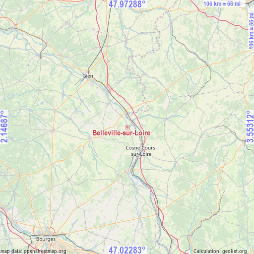
Belleville-sur-Loire GPS coordinates[2]
47° 30' 0" North, 2° 51' 0" East
| Map corner | latitude | longitude |
|---|---|---|
| Upper-left | 47.97288°, | 2.14687° |
| Center: | 47.5°, | 2.85° |
| Lower-right: | 47.02283°, | 3.55312° |
| Map W x H: | 105.6×105.6 km | = 65.6×65.6mi |
| max Lat: | 51.07786° ⇑48.8% North |
| Belleville-sur-Loire: | 47.5° |
| min Lat: | ⇓51.2% South 41.3874° |
| min Long | Belleville-sur- | max Long |
| -5.08615° | 2.85° | 9.52242° |
| W 55.7%⇐ | ⇒44.3% E |
Elevation
Elevation of Belleville-sur-Loire is 141 m = 463 ft, and this is 52.7 m = 173 ft below average elevation for this country.
| Max E: |
2333 m = 7654 ft | 47.5% |
| Avg. | 193.7 m = 635 ft | |
| Belleville-sur-Loire | 141 m = 463 ft | |
Min E: |
-1 m = -3 ft | 52.5% |
See also: France elevation on elevation.city.
Geographical zone
Belleville-sur-Loire is located in North temperate zone (between Tropic of Cancer and the Arctic Circle). Distance of this North polar circle is 2119.7 km =1317.1 mi to North.| Distance of | km | miles | from Belleville-sur-Loire |
|---|---|---|---|
| North Pole | 4725.6 | 2936.4 | to North |
| Arctic Circle | 2119.7 | 1317.1 | to North |
| Tropic Cancer | 2675.6 | 1662.5 | to South |
| Equator | 5281.5 | 3281.8 | to South |


Nearby cities:
15 places around Belleville-sur-Loire: (largest is in red/bold)
• Arquian
11.4 km =7.1 mi,  65°
65°
• Bannay
12.7 km =7.9 mi,  168°
168°
• Bonny-sur-Loire
6.9 km =4.3 mi,  353°
353°
• Boulleret
8.6 km =5.3 mi, 168°
• Cosne-Cours-sur-Loire
11.4 km =7.1 mi,  150°
150°
• La Celle-sur-Loire
6.7 km =4.2 mi,  117°
117°
• Léré
3.8 km =2.4 mi,  156°
156°
• Myennes
8.7 km =5.4 mi,  133°
133°
• Neuvy-sur-Loire
3.6 km =2.2 mi,  44°
44°
• Ousson-sur-Loire
11.1 km =6.9 mi,  334°
334°
• Saint-Firmin-sur-Loire
16.5 km =10.3 mi, 327°
• Savigny-en-Sancerre
7.2 km =4.5 mi,  205°
205°
• Sury-en-Vaux
15.1 km =9.4 mi,  193°
193°
• Sury-près-Léré
2.2 km =1.4 mi,  142°
142°
• Vailly-sur-Sauldre
15.7 km =9.8 mi,  253°
253°
Sources, notices
• [Note1] Compared only with cities in France existing in our database
• [Src1] Map data: © OpenStreetMap contributors (CC-BY-SA)
• [Src2] Other city data from geonames.org with taken over terms of usage.
• [Src3] Geographical zone / Annual Mean Temperature by Robert A. Rohde @ Wikipedia
