Savigny-en-Sancerre geodata
Savigny-en-Sancerre (Centre) is a populated place; located in France in Europe/Paris (GMT+2) time zone. With population of 1,074 people, there are 8304 cities with bigger population in this country. Compared to other cities in France, 50.4% of cities are located further ↓South; 55.1% of cities are located further ←West and 69.2% of cities have lower elevation than Savigny-en-Sancerre. Note1
Administrative division(s):
- Level 1: Centre
- Level 2: Cher
- Level 3: Arrondissement de Bourges
- Level 4: Savigny-en-Sancerre


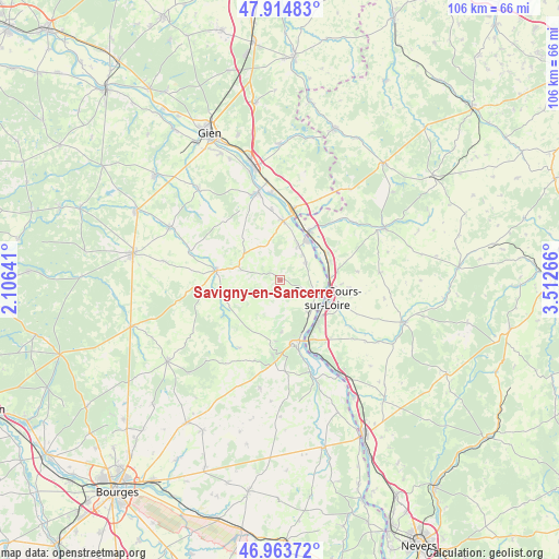
Savigny-en-Sancerre GPS coordinates[2]
47° 26' 29.112" North, 2° 48' 34.308" East
| Map corner | latitude | longitude |
|---|---|---|
| Upper-left | 47.91483°, | 2.10641° |
| Center: | 47.44142°, | 2.80953° |
| Lower-right: | 46.96372°, | 3.51266° |
| Map W x H: | 105.8×105.8 km | = 65.7×65.7mi |
| max Lat: | 51.07786° ⇑49.6% North |
| Savigny-en-Sancerre: | 47.44142° |
| min Lat: | ⇓50.4% South 41.3874° |
| min Long | Savigny-en-Sanc | max Long |
| -5.08615° | 2.80953° | 9.52242° |
| W 55.1%⇐ | ⇒44.9% E |
Elevation
Elevation of Savigny-en-Sancerre is 215 m = 705 ft, and this is 21.3 m = 70 ft above average elevation for this country.
| Max E: |
2333 m = 7654 ft | 30.8% |
| Savigny-en-Sancerre | 215 m 705 ft | |
| Avg. | 193.7 m = 635 ft | |
Min E: |
-1 m = -3 ft | 69.2% |
See also: France elevation on elevation.city.
Geographical zone
Savigny-en-Sancerre is located in North temperate zone (between Tropic of Cancer and the Arctic Circle). Distance of this North polar circle is 2126.2 km =1321.2 mi to North.| Distance of | km | miles | from Savigny-en-Sancerre |
|---|---|---|---|
| North Pole | 4732.1 | 2940.4 | to North |
| Arctic Circle | 2126.2 | 1321.2 | to North |
| Tropic Cancer | 2669.1 | 1658.5 | to South |
| Equator | 5275 | 3277.7 | to South |


Nearby cities:
15 places around Savigny-en-Sancerre: (largest is in red/bold)
• Bannay
8.2 km =5.1 mi,  136°
136°
• Belleville-sur-Loire
7.2 km =4.5 mi,  25°
25°
• Bonny-sur-Loire
13.6 km =8.5 mi,  9°
9°
• Boulleret
5.2 km =3.2 mi,  111°
111°
• Cosne-Cours-sur-Loire
9.3 km =5.8 mi, 111°
• Jars
10.9 km =6.8 mi,  241°
241°
• La Celle-sur-Loire
9.6 km =6 mi,  69°
69°
• Léré
5.5 km =3.4 mi,  56°
56°
• Myennes
9.3 km =5.8 mi,  86°
86°
• Neuvy-sur-Loire
10.7 km =6.6 mi, 31°
• Saint-Satur
11.6 km =7.2 mi,  169°
169°
• Sancerre
12.7 km =7.9 mi, 171°
• Sury-en-Vaux
8.2 km =5.1 mi,  182°
182°
• Sury-près-Léré
6.5 km =4 mi,  42°
42°
• Vailly-sur-Sauldre
12.2 km =7.6 mi,  279°
279°
Sources, notices
• [Note1] Compared only with cities in France existing in our database
• [Src1] Map data: © OpenStreetMap contributors (CC-BY-SA)
• [Src2] Other city data from geonames.org with taken over terms of usage.
• [Src3] Geographical zone / Annual Mean Temperature by Robert A. Rohde @ Wikipedia
