Forges-les-Bains geodata
Forges-les-Bains (Île-de-France) is a populated place; located in France in Europe/Paris (GMT+2) time zone. With population of 3,694 people, there are 2662 cities with bigger population in this country. Compared to other cities in France, 71.5% of cities are located further ↓South; 55.8% of cities are located further →East and 54.8% of cities have higher elevation than Forges-les-Bains. Note1
Administrative division(s):
- Level 1: Île-de-France
- Level 2: Département de l'Essonne
- Level 3: Arrondissement de Palaiseau
- Level 4: Forges-les-Bains


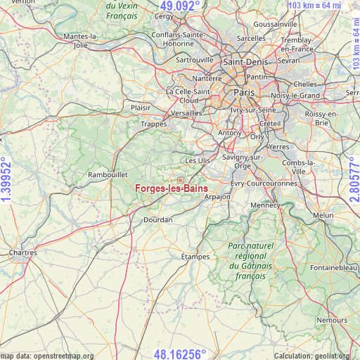
Forges-les-Bains GPS coordinates[2]
48° 37' 45.912" North, 2° 6' 9.504" East
| Map corner | latitude | longitude |
|---|---|---|
| Upper-left | 49.092°, | 1.39952° |
| Center: | 48.62942°, | 2.10264° |
| Lower-right: | 48.16256°, | 2.80577° |
| Map W x H: | 103.3×103.3 km | = 64.2×64.2mi |
| max Lat: | 51.07786° ⇑28.5% North |
| Forges-les-Bains: | 48.62942° |
| min Lat: | ⇓71.5% South 41.3874° |
| min Long | Forges-les-Bain | max Long |
| -5.08615° | 2.10264° | 9.52242° |
| W 44.2%⇐ | ⇒55.8% E |
Elevation
Elevation of Forges-les-Bains is 117 m = 384 ft, and this is 76.7 m = 252 ft below average elevation for this country.
| Max E: |
2333 m = 7654 ft | 54.8% |
| Avg. | 193.7 m = 635 ft | |
| Forges-les-Bains | 117 m = 384 ft | |
Min E: |
-1 m = -3 ft | 45.2% |
See also: France elevation on elevation.city.
Geographical zone
Forges-les-Bains is located in North temperate zone (between Tropic of Cancer and the Arctic Circle). Distance of this North polar circle is 1994.1 km =1239.1 mi to North.| Distance of | km | miles | from Forges-les-Bains |
|---|---|---|---|
| North Pole | 4600 | 2858.3 | to North |
| Arctic Circle | 1994.1 | 1239.1 | to North |
| Tropic Cancer | 2801.2 | 1740.6 | to South |
| Equator | 5407.1 | 3359.8 | to South |


Nearby cities:
15 places around Forges-les-Bains: (largest is in red/bold)
• Angervilliers
4.9 km =3 mi,  213°
213°
• Bonnelles
5.5 km =3.4 mi,  256°
256°
• Boullay-les-Troux
6.8 km =4.2 mi,  324°
324°
• Briis-sous-Forges
1.5 km =0.9 mi,  113°
113°
• Courson-Monteloup
4.7 km =2.9 mi,  133°
133°
• Fontenay-lès-Briis
3.8 km =2.4 mi, 106°
• Gif-sur-Yvette
6.4 km =4 mi,  20°
20°
• Gometz-la-Ville
5.1 km =3.2 mi, 21°
• Gometz-le-Châtel
6 km =3.7 mi,  25°
25°
• Janvry
4.2 km =2.6 mi,  60°
60°
• Les Molières
5.4 km =3.4 mi,  333°
333°
• Limours
2.7 km =1.7 mi,  314°
314°
• Pecqueuse
4.5 km =2.8 mi,  295°
295°
• Saint-Maurice-Montcouronne
5.4 km =3.4 mi,  162°
162°
• Vaugrigneuse
3.3 km =2.1 mi,  154°
154°
Sources, notices
• [Note1] Compared only with cities in France existing in our database
• [Src1] Map data: © OpenStreetMap contributors (CC-BY-SA)
• [Src2] Other city data from geonames.org with taken over terms of usage.
• [Src3] Geographical zone / Annual Mean Temperature by Robert A. Rohde @ Wikipedia
