Boisset-et-Gaujac geodata
Boisset-et-Gaujac (Occitanie) is a populated place; located in France in Europe/Paris (GMT+2) time zone. With population of 2,181 people, there are 4402 cities with bigger population in this country. Compared to other cities in France, 86.7% of cities are located further ↑North; 67.9% of cities are located further ←West and 59.3% of cities have lower elevation than Boisset-et-Gaujac. Note1
Administrative division(s):
- Level 1: Occitanie
- Level 2: Gard
- Level 3: Arrondissement d’Alès
- Level 4: Boisset-et-Gaujac


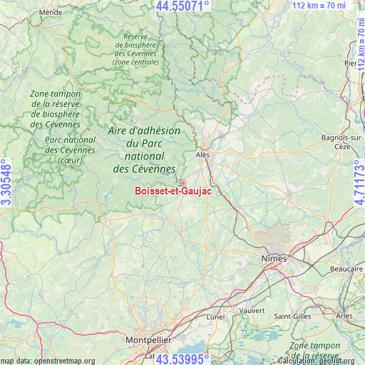
Boisset-et-Gaujac GPS coordinates[2]
44° 2' 50.964" North, 4° 0' 30.996" East
| Map corner | latitude | longitude |
|---|---|---|
| Upper-left | 44.55071°, | 3.30548° |
| Center: | 44.04749°, | 4.00861° |
| Lower-right: | 43.53995°, | 4.71173° |
| Map W x H: | 112.4×112.4 km | = 69.8×69.8mi |
| max Lat: | 51.07786° ⇑86.7% North |
| Boisset-et-Gaujac: | 44.04749° |
| min Lat: | ⇓13.3% South 41.3874° |
| min Long | Boisset-et-Gauj | max Long |
| -5.08615° | 4.00861° | 9.52242° |
| W 67.9%⇐ | ⇒32.1% E |
Elevation
Elevation of Boisset-et-Gaujac is 167 m = 548 ft, and this is 26.7 m = 88 ft below average elevation for this country.
| Max E: |
2333 m = 7654 ft | 40.7% |
| Avg. | 193.7 m = 635 ft | |
| Boisset-et-Gaujac | 167 m = 548 ft | |
Min E: |
-1 m = -3 ft | 59.3% |
See also: France elevation on elevation.city.
Geographical zone
Boisset-et-Gaujac is located in North temperate zone (between Tropic of Cancer and the Arctic Circle). Distance of this Northern Tropic circle is 2291.7 km =1424 mi to South.| Distance of | km | miles | from Boisset-et-Gaujac |
|---|---|---|---|
| North Pole | 5109.4 | 3174.8 | to North |
| Arctic Circle | 2503.6 | 1555.7 | to North |
| Tropic Cancer | 2291.7 | 1424 | to South |
| Equator | 4897.6 | 3043.2 | to South |


Nearby cities:
15 places around Boisset-et-Gaujac: (largest is in red/bold)
• Alès
10.4 km =6.5 mi,  33°
33°
• Anduze
2 km =1.2 mi,  291°
291°
• Bagard
4.4 km =2.7 mi,  52°
52°
• Cardet
6.2 km =3.9 mi,  112°
112°
• Durfort-et-Saint-Martin-de-Sossenac
7.7 km =4.8 mi,  213°
213°
• Générargues
4.3 km =2.7 mi,  332°
332°
• Lédignan
10.3 km =6.4 mi,  130°
130°
• Lézan
4.8 km =3 mi,  136°
136°
• Massillargues-Attuech
3.8 km =2.4 mi,  161°
161°
• Mialet
8.8 km =5.5 mi,  323°
323°
• Ribaute-les-Tavernes
5.9 km =3.7 mi,  101°
101°
• Saint-Christol-lès-Alès
6.6 km =4.1 mi, 53°
• Saint-Hilaire-de-Brethmas
10 km =6.2 mi,  68°
68°
• Tornac
3.1 km =1.9 mi,  199°
199°
• Vézénobres
10.3 km =6.4 mi,  87°
87°
Sources, notices
• [Note1] Compared only with cities in France existing in our database
• [Src1] Map data: © OpenStreetMap contributors (CC-BY-SA)
• [Src2] Other city data from geonames.org with taken over terms of usage.
• [Src3] Geographical zone / Annual Mean Temperature by Robert A. Rohde @ Wikipedia
