Bagard geodata
Bagard (Occitanie) is a populated place; located in France in Europe/Paris (GMT+2) time zone. With population of 2,200 people, there are 4366 cities with bigger population in this country. Compared to other cities in France, 86.5% of cities are located further ↑North; 68.4% of cities are located further ←West and 55.6% of cities have lower elevation than Bagard. Note1
Administrative division(s):
- Level 1: Occitanie
- Level 2: Gard
- Level 3: Arrondissement d’Alès
- Level 4: Bagard


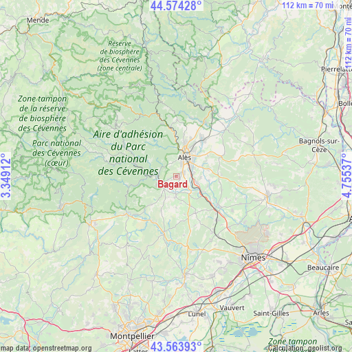
Bagard GPS coordinates[2]
44° 4' 16.536" North, 4° 3' 8.1" East
| Map corner | latitude | longitude |
|---|---|---|
| Upper-left | 44.57428°, | 3.34912° |
| Center: | 44.07126°, | 4.05225° |
| Lower-right: | 43.56393°, | 4.75537° |
| Map W x H: | 112.3×112.3 km | = 69.8×69.8mi |
| max Lat: | 51.07786° ⇑86.5% North |
| Bagard: | 44.07126° |
| min Lat: | ⇓13.5% South 41.3874° |
| min Long | Bagard | max Long |
| -5.08615° | 4.05225° | 9.52242° |
| W 68.4%⇐ | ⇒31.6% E |
Elevation
Elevation of Bagard is 152 m = 499 ft, and this is 41.7 m = 137 ft below average elevation for this country.
| Max E: |
2333 m = 7654 ft | 44.4% |
| Avg. | 193.7 m = 635 ft | |
| Bagard | 152 m = 499 ft | |
Min E: |
-1 m = -3 ft | 55.6% |
See also: France elevation on elevation.city.
Geographical zone
Bagard is located in North temperate zone (between Tropic of Cancer and the Arctic Circle). Distance of this Northern Tropic circle is 2294.3 km =1425.6 mi to South.| Distance of | km | miles | from Bagard |
|---|---|---|---|
| North Pole | 5106.8 | 3173.2 | to North |
| Arctic Circle | 2500.9 | 1554 | to North |
| Tropic Cancer | 2294.3 | 1425.6 | to South |
| Equator | 4900.3 | 3044.9 | to South |


Nearby cities:
15 places around Bagard: (largest is in red/bold)
• Alès
6.4 km =4 mi,  20°
20°
• Anduze
5.7 km =3.5 mi,  250°
250°
• Boisset-et-Gaujac
4.4 km =2.7 mi,  232°
232°
• Cardet
5.5 km =3.4 mi,  155°
155°
• Cendras
8.8 km =5.5 mi,  7°
7°
• Deaux
7.8 km =4.8 mi,  93°
93°
• Générargues
5.6 km =3.5 mi,  282°
282°
• Lézan
6.1 km =3.8 mi,  181°
181°
• Massillargues-Attuech
6.6 km =4.1 mi,  199°
199°
• Méjannes-lès-Alès
8.8 km =5.5 mi,  69°
69°
• Ribaute-les-Tavernes
4.4 km =2.7 mi,  149°
149°
• Saint-Christol-lès-Alès
2.2 km =1.4 mi,  55°
55°
• Saint-Hilaire-de-Brethmas
5.9 km =3.7 mi,  80°
80°
• Tornac
7.1 km =4.4 mi,  219°
219°
• Vézénobres
7.2 km =4.5 mi,  107°
107°
Sources, notices
• [Note1] Compared only with cities in France existing in our database
• [Src1] Map data: © OpenStreetMap contributors (CC-BY-SA)
• [Src2] Other city data from geonames.org with taken over terms of usage.
• [Src3] Geographical zone / Annual Mean Temperature by Robert A. Rohde @ Wikipedia
