Boisset geodata
Boisset (Auvergne-Rhône-Alpes) is a populated place; located in France in Europe/Paris (GMT+2) time zone. With population of 656 people, there are 12440 cities with bigger population in this country. Compared to other cities in France, 81.5% of cities are located further ↑North; 53.5% of cities are located further →East and 90.1% of cities have lower elevation than Boisset. Note1
Administrative division(s):
- Level 1: Auvergne-Rhône-Alpes
- Level 2: Cantal
- Level 3: Aurillac
- Level 4: Boisset


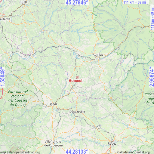
Boisset GPS coordinates[2]
44° 46' 57.18" North, 2° 15' 12.996" East
| Map corner | latitude | longitude |
|---|---|---|
| Upper-left | 45.27946°, | 1.55049° |
| Center: | 44.78255°, | 2.25361° |
| Lower-right: | 44.28133°, | 2.95674° |
| Map W x H: | 111×111 km | = 69×69mi |
| max Lat: | 51.07786° ⇑81.5% North |
| Boisset: | 44.78255° |
| min Lat: | ⇓18.5% South 41.3874° |
| min Long | Boisset | max Long |
| -5.08615° | 2.25361° | 9.52242° |
| W 46.5%⇐ | ⇒53.5% E |
Elevation
Elevation of Boisset is 429 m = 1407 ft, and this is 235.3 m = 772 ft above average elevation for this country.
| Max E: |
2333 m = 7654 ft | 9.9% |
| Boisset | 429 m 1407 ft | |
| Avg. | 193.7 m = 635 ft | |
Min E: |
-1 m = -3 ft | 90.1% |
See also: France elevation on elevation.city.
Geographical zone
Boisset is located in North temperate zone (between Tropic of Cancer and the Arctic Circle). Distance of this Northern Tropic circle is 2373.4 km =1474.8 mi to South.| Distance of | km | miles | from Boisset |
|---|---|---|---|
| North Pole | 5027.7 | 3124.1 | to North |
| Arctic Circle | 2421.8 | 1504.8 | to North |
| Tropic Cancer | 2373.4 | 1474.8 | to South |
| Equator | 4979.4 | 3094.1 | to South |


Nearby cities:
15 places around Boisset: (largest is in red/bold)
• Bagnac-sur-Célé
14.6 km =9.1 mi,  208°
208°
• Cassaniouze
14.4 km =8.9 mi,  134°
134°
• Lafeuillade-en-Vézie
16.3 km =10.1 mi,  87°
87°
• Latronquière
14 km =8.7 mi,  278°
278°
• Le Rouget
8.2 km =5.1 mi,  347°
347°
• Marcolès
7.9 km =4.9 mi, 90°
• Maurs
9.1 km =5.7 mi, 208°
• Prunet
17.1 km =10.6 mi,  75°
75°
• Roannes-Saint-Mary
13.6 km =8.5 mi,  52°
52°
• Saint-Constant
11 km =6.8 mi,  189°
189°
• Saint-Mamet-la-Salvetat
9.4 km =5.8 mi,  26°
26°
• Saint-Santin
15 km =9.3 mi, 191°
• Saint-Étienne-de-Maurs
8.2 km =5.1 mi, 206°
• Sansac-de-Marmiesse
13.5 km =8.4 mi, 33°
• Ytrac
16.8 km =10.4 mi, 30°
Sources, notices
• [Note1] Compared only with cities in France existing in our database
• [Src1] Map data: © OpenStreetMap contributors (CC-BY-SA)
• [Src2] Other city data from geonames.org with taken over terms of usage.
• [Src3] Geographical zone / Annual Mean Temperature by Robert A. Rohde @ Wikipedia
