Maurs geodata
Maurs (Auvergne-Rhône-Alpes) is a populated place; located in France in Europe/Paris (GMT+2) time zone. With population of 2,269 people, there are 4247 cities with bigger population in this country. Compared to other cities in France, 82% of cities are located further ↑North; 54.5% of cities are located further →East and 80.1% of cities have lower elevation than Maurs. Note1
Administrative division(s):
- Level 1: Auvergne-Rhône-Alpes
- Level 2: Cantal
- Level 3: Aurillac
- Level 4: Maurs


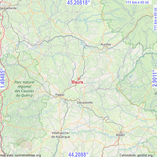
Maurs GPS coordinates[2]
44° 42' 38.34" North, 2° 11' 52.692" East
| Map corner | latitude | longitude |
|---|---|---|
| Upper-left | 45.20818°, | 1.49485° |
| Center: | 44.71065°, | 2.19797° |
| Lower-right: | 44.2088°, | 2.9011° |
| Map W x H: | 111.1×111.1 km | = 69×69mi |
| max Lat: | 51.07786° ⇑82% North |
| Maurs: | 44.71065° |
| min Lat: | ⇓18% South 41.3874° |
| min Long | Maurs | max Long |
| -5.08615° | 2.19797° | 9.52242° |
| W 45.5%⇐ | ⇒54.5% E |
Elevation
Elevation of Maurs is 291 m = 955 ft, and this is 97.3 m = 319 ft above average elevation for this country.
| Max E: |
2333 m = 7654 ft | 19.9% |
| Maurs | 291 m 955 ft | |
| Avg. | 193.7 m = 635 ft | |
Min E: |
-1 m = -3 ft | 80.1% |
See also: France elevation on elevation.city.
Geographical zone
Maurs is located in North temperate zone (between Tropic of Cancer and the Arctic Circle). Distance of this Northern Tropic circle is 2365.4 km =1469.8 mi to South.| Distance of | km | miles | from Maurs |
|---|---|---|---|
| North Pole | 5035.7 | 3129 | to North |
| Arctic Circle | 2429.8 | 1509.8 | to North |
| Tropic Cancer | 2365.4 | 1469.8 | to South |
| Equator | 4971.4 | 3089.1 | to South |


Nearby cities:
15 places around Maurs: (largest is in red/bold)
• Bagnac-sur-Célé
5.5 km =3.4 mi,  206°
206°
• Boisse-Penchot
13.2 km =8.2 mi,  176°
176°
• Boisset
9.1 km =5.7 mi,  28°
28°
• Cardaillac
16.2 km =10.1 mi,  257°
257°
• Cassaniouze
14.8 km =9.2 mi,  98°
98°
• Decazeville
17.2 km =10.7 mi,  165°
165°
• Flagnac
12.4 km =7.7 mi,  161°
161°
• Latronquière
13.8 km =8.6 mi,  316°
316°
• Le Rouget
16.2 km =10.1 mi,  9°
9°
• Livinhac-le-Haut
13.4 km =8.3 mi, 168°
• Marcolès
14.6 km =9.1 mi,  57°
57°
• Saint-Constant
3.9 km =2.4 mi,  137°
137°
• Saint-Santin
6.9 km =4.3 mi, 167°
• Saint-Étienne-de-Maurs
0.9 km =0.6 mi,  47°
47°
• Viviez
17.2 km =10.7 mi, 175°
Sources, notices
• [Note1] Compared only with cities in France existing in our database
• [Src1] Map data: © OpenStreetMap contributors (CC-BY-SA)
• [Src2] Other city data from geonames.org with taken over terms of usage.
• [Src3] Geographical zone / Annual Mean Temperature by Robert A. Rohde @ Wikipedia
