Boisredon geodata
Boisredon (Nouvelle-Aquitaine) is a populated place; located in France in Europe/Paris (GMT+2) time zone. With population of 635 people, there are 12740 cities with bigger population in this country. Compared to other cities in France, 76.2% of cities are located further ↑North; 83.8% of cities are located further →East and 84.9% of cities have higher elevation than Boisredon. Note1
Administrative division(s):
- Level 1: Nouvelle-Aquitaine
- Level 2: Charente-Maritime
- Level 3: Arrondissement de Jonzac
- Level 4: Boisredon


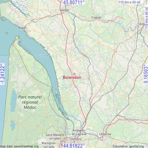
Boisredon GPS coordinates[2]
45° 18' 53.352" North, 0° 32' 17.16" West
| Map corner | latitude | longitude |
|---|---|---|
| Upper-left | 45.80711°, | -1.24122° |
| Center: | 45.31482°, | -0.5381° |
| Lower-right: | 44.81822°, | 0.16503° |
| Map W x H: | 110×110 km | = 68.4×68.4mi |
| max Lat: | 51.07786° ⇑76.2% North |
| Boisredon: | 45.31482° |
| min Lat: | ⇓23.8% South 41.3874° |
| min Long | Boisredon | max Long |
| -5.08615° | -0.5381° | 9.52242° |
| W 16.2%⇐ | ⇒83.8% E |
Elevation
Elevation of Boisredon is 42 m = 138 ft, and this is 151.7 m = 498 ft below average elevation for this country.
| Max E: |
2333 m = 7654 ft | 84.9% |
| Avg. | 193.7 m = 635 ft | |
| Boisredon | 42 m = 138 ft | |
Min E: |
-1 m = -3 ft | 15.1% |
See also: France elevation on elevation.city.
Geographical zone
Boisredon is located in North temperate zone (between Tropic of Cancer and the Arctic Circle). Distance of this North polar circle is 2362.6 km =1468.1 mi to North.| Distance of | km | miles | from Boisredon |
|---|---|---|---|
| North Pole | 4968.5 | 3087.3 | to North |
| Arctic Circle | 2362.6 | 1468.1 | to North |
| Tropic Cancer | 2432.6 | 1511.5 | to South |
| Equator | 5038.5 | 3130.8 | to South |


Nearby cities:
15 places around Boisredon: (largest is in red/bold)
• Anglade
14 km =8.7 mi,  212°
212°
• Braud-et-Saint-Louis
10.1 km =6.3 mi,  221°
221°
• Donnezac
10.6 km =6.6 mi,  135°
135°
• Marcillac
5.2 km =3.2 mi,  167°
167°
• Mirambeau
7 km =4.3 mi,  338°
338°
• Montendre
10.8 km =6.7 mi,  108°
108°
• Nieul-le-Virouil
10.5 km =6.5 mi,  3°
3°
• Ozillac
14.3 km =8.9 mi,  52°
52°
• Reignac
9.3 km =5.8 mi,  164°
164°
• Saint-Aubin-de-Blaye
5.6 km =3.5 mi,  197°
197°
• Saint-Bonnet-sur-Gironde
10.5 km =6.5 mi,  294°
294°
• Saint-Ciers-du-Taillon
14.4 km =8.9 mi,  326°
326°
• Saint-Ciers-sur-Gironde
6.2 km =3.9 mi,  241°
241°
• Saint-Simon-de-Bordes
11.1 km =6.9 mi,  35°
35°
• Étauliers
10.3 km =6.4 mi, 195°
Sources, notices
• [Note1] Compared only with cities in France existing in our database
• [Src1] Map data: © OpenStreetMap contributors (CC-BY-SA)
• [Src2] Other city data from geonames.org with taken over terms of usage.
• [Src3] Geographical zone / Annual Mean Temperature by Robert A. Rohde @ Wikipedia
