Blacé geodata
Blacé (Auvergne-Rhône-Alpes) is a populated place; located in France in Europe/Paris (GMT+2) time zone. With population of 1,290 people, there are 7081 cities with bigger population in this country. Compared to other cities in France, 65.9% of cities are located further ↑North; 73.2% of cities are located further ←West and 80.8% of cities have lower elevation than Blacé. Note1
Administrative division(s):
- Level 1: Auvergne-Rhône-Alpes
- Level 2: Département du Rhône
- Level 3: Arrondissement de Villefranche-sur-Saône
- Level 4: Blacé


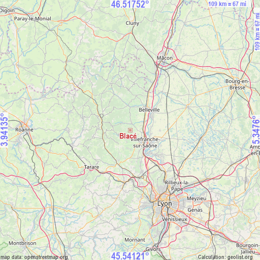
Blacé GPS coordinates[2]
46° 1' 53.472" North, 4° 38' 40.128" East
| Map corner | latitude | longitude |
|---|---|---|
| Upper-left | 46.51752°, | 3.94135° |
| Center: | 46.03152°, | 4.64448° |
| Lower-right: | 45.54121°, | 5.3476° |
| Map W x H: | 108.6×108.6 km | = 67.5×67.5mi |
| max Lat: | 51.07786° ⇑65.9% North |
| Blacé: | 46.03152° |
| min Lat: | ⇓34.1% South 41.3874° |
| min Long | Blacé | max Long |
| -5.08615° | 4.64448° | 9.52242° |
| W 73.2%⇐ | ⇒26.8% E |
Elevation
Elevation of Blacé is 299 m = 981 ft, and this is 105.3 m = 345 ft above average elevation for this country.
| Max E: |
2333 m = 7654 ft | 19.2% |
| Blacé | 299 m 981 ft | |
| Avg. | 193.7 m = 635 ft | |
Min E: |
-1 m = -3 ft | 80.8% |
See also: France elevation on elevation.city.
Geographical zone
Blacé is located in North temperate zone (between Tropic of Cancer and the Arctic Circle). Distance of this North polar circle is 2282.9 km =1418.5 mi to North.| Distance of | km | miles | from Blacé |
|---|---|---|---|
| North Pole | 4888.8 | 3037.8 | to North |
| Arctic Circle | 2282.9 | 1418.5 | to North |
| Tropic Cancer | 2512.3 | 1561.1 | to South |
| Equator | 5118.2 | 3180.3 | to South |


Nearby cities:
15 places around Blacé: (largest is in red/bold)
• Arnas
5 km =3.1 mi,  100°
100°
• Charentay
6.9 km =4.3 mi,  22°
22°
• Cogny
5.1 km =3.2 mi,  197°
197°
• Denicé
3.3 km =2.1 mi,  178°
178°
• Gleizé
6.2 km =3.9 mi,  139°
139°
• Lacenas
4.9 km =3 mi, 179°
• Le Perréon
4.9 km =3 mi,  315°
315°
• Liergues
6.8 km =4.2 mi,  168°
168°
• Odenas
6.3 km =3.9 mi,  1°
1°
• Rivolet
4.4 km =2.7 mi,  228°
228°
• Saint-Georges-de-Reneins
6.8 km =4.2 mi,  60°
60°
• Saint-Julien
0.8 km =0.5 mi,  134°
134°
• Saint-Étienne-des-Oullières
4 km =2.5 mi,  5°
5°
• Saint-Étienne-la-Varenne
5.1 km =3.2 mi,  347°
347°
• Vaux-en-Beaujolais
4.9 km =3 mi,  303°
303°
Sources, notices
• [Note1] Compared only with cities in France existing in our database
• [Src1] Map data: © OpenStreetMap contributors (CC-BY-SA)
• [Src2] Other city data from geonames.org with taken over terms of usage.
• [Src3] Geographical zone / Annual Mean Temperature by Robert A. Rohde @ Wikipedia
