Denicé geodata
Denicé (Auvergne-Rhône-Alpes) is a populated place; located in France in Europe/Paris (GMT+2) time zone. With population of 1,355 people, there are 6787 cities with bigger population in this country. Compared to other cities in France, 66.2% of cities are located further ↑North; 73.2% of cities are located further ←West and 78.6% of cities have lower elevation than Denicé. Note1
Administrative division(s):
- Level 1: Auvergne-Rhône-Alpes
- Level 2: Département du Rhône
- Level 3: Arrondissement de Villefranche-sur-Saône
- Level 4: Denicé


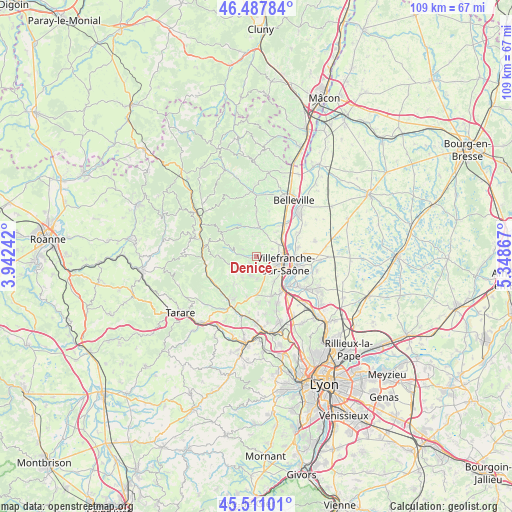
Denicé GPS coordinates[2]
46° 0' 5.688" North, 4° 38' 43.98" East
| Map corner | latitude | longitude |
|---|---|---|
| Upper-left | 46.48784°, | 3.94242° |
| Center: | 46.00158°, | 4.64555° |
| Lower-right: | 45.51101°, | 5.34867° |
| Map W x H: | 108.6×108.6 km | = 67.5×67.5mi |
| max Lat: | 51.07786° ⇑66.2% North |
| Denicé: | 46.00158° |
| min Lat: | ⇓33.8% South 41.3874° |
| min Long | Denicé | max Long |
| -5.08615° | 4.64555° | 9.52242° |
| W 73.2%⇐ | ⇒26.8% E |
Elevation
Elevation of Denicé is 278 m = 912 ft, and this is 84.3 m = 277 ft above average elevation for this country.
| Max E: |
2333 m = 7654 ft | 21.4% |
| Denicé | 278 m 912 ft | |
| Avg. | 193.7 m = 635 ft | |
Min E: |
-1 m = -3 ft | 78.6% |
See also: France elevation on elevation.city.
Geographical zone
Denicé is located in North temperate zone (between Tropic of Cancer and the Arctic Circle). Distance of this North polar circle is 2286.3 km =1420.6 mi to North.| Distance of | km | miles | from Denicé |
|---|---|---|---|
| North Pole | 4892.2 | 3039.9 | to North |
| Arctic Circle | 2286.3 | 1420.6 | to North |
| Tropic Cancer | 2509 | 1559 | to South |
| Equator | 5114.9 | 3178.3 | to South |


Nearby cities:
15 places around Denicé: (largest is in red/bold)
• Arnas
5.4 km =3.4 mi,  63°
63°
• Blacé
3.3 km =2.1 mi,  358°
358°
• Cogny
2.2 km =1.4 mi,  225°
225°
• Gleizé
4.2 km =2.6 mi,  109°
109°
• Jarnioux
4.3 km =2.7 mi,  198°
198°
• Lacenas
1.6 km =1 mi,  182°
182°
• Liergues
3.6 km =2.2 mi,  158°
158°
• Limas
5.5 km =3.4 mi,  121°
121°
• Pommiers
6.3 km =3.9 mi,  144°
144°
• Pouilly-le-Monial
4.9 km =3 mi, 178°
• Rivolet
3.4 km =2.1 mi,  277°
277°
• Saint-Julien
2.8 km =1.7 mi,  10°
10°
• Theizé
7.2 km =4.5 mi, 198°
• Ville-sur-Jarnioux
5.3 km =3.3 mi,  213°
213°
• Villefranche-sur-Saône
5.9 km =3.7 mi,  103°
103°
Sources, notices
• [Note1] Compared only with cities in France existing in our database
• [Src1] Map data: © OpenStreetMap contributors (CC-BY-SA)
• [Src2] Other city data from geonames.org with taken over terms of usage.
• [Src3] Geographical zone / Annual Mean Temperature by Robert A. Rohde @ Wikipedia
