Odenas geodata
Odenas (Auvergne-Rhône-Alpes) is a populated place; located in France in Europe/Paris (GMT+2) time zone. With population of 680 people, there are 12068 cities with bigger population in this country. Compared to other cities in France, 65.2% of cities are located further ↑North; 73.2% of cities are located further ←West and 81.1% of cities have lower elevation than Odenas. Note1
Administrative division(s):
- Level 1: Auvergne-Rhône-Alpes
- Level 2: Département du Rhône
- Level 3: Arrondissement de Villefranche-sur-Saône
- Level 4: Odenas


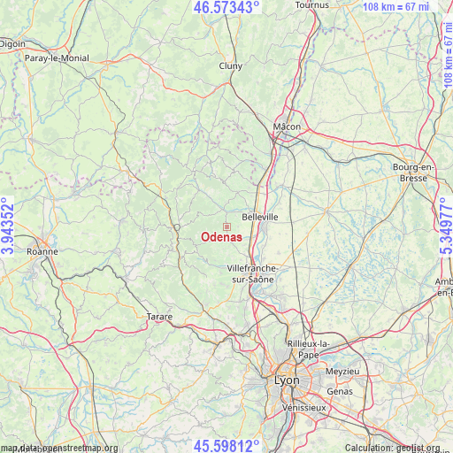
Odenas GPS coordinates[2]
46° 5' 16.548" North, 4° 38' 47.94" East
| Map corner | latitude | longitude |
|---|---|---|
| Upper-left | 46.57343°, | 3.94352° |
| Center: | 46.08793°, | 4.64665° |
| Lower-right: | 45.59812°, | 5.34977° |
| Map W x H: | 108.4×108.4 km | = 67.4×67.4mi |
| max Lat: | 51.07786° ⇑65.2% North |
| Odenas: | 46.08793° |
| min Lat: | ⇓34.8% South 41.3874° |
| min Long | Odenas | max Long |
| -5.08615° | 4.64665° | 9.52242° |
| W 73.2%⇐ | ⇒26.8% E |
Elevation
Elevation of Odenas is 301 m = 988 ft, and this is 107.3 m = 352 ft above average elevation for this country.
| Max E: |
2333 m = 7654 ft | 18.9% |
| Odenas | 301 m 988 ft | |
| Avg. | 193.7 m = 635 ft | |
Min E: |
-1 m = -3 ft | 81.1% |
See also: France elevation on elevation.city.
Geographical zone
Odenas is located in North temperate zone (between Tropic of Cancer and the Arctic Circle). Distance of this North polar circle is 2276.7 km =1414.7 mi to North.| Distance of | km | miles | from Odenas |
|---|---|---|---|
| North Pole | 4882.6 | 3033.9 | to North |
| Arctic Circle | 2276.7 | 1414.7 | to North |
| Tropic Cancer | 2518.6 | 1565 | to South |
| Equator | 5124.5 | 3184.2 | to South |


Nearby cities:
15 places around Odenas: (largest is in red/bold)
• Arnas
8.6 km =5.3 mi,  146°
146°
• Belleville
8.2 km =5.1 mi,  73°
73°
• Blacé
6.3 km =3.9 mi,  181°
181°
• Cercié
4 km =2.5 mi,  27°
27°
• Charentay
2.5 km =1.6 mi,  87°
87°
• Durette
5.3 km =3.3 mi,  8°
8°
• Lantignié
6.8 km =4.2 mi,  344°
344°
• Le Perréon
4.5 km =2.8 mi,  232°
232°
• Quincié-en-Beaujolais
4.2 km =2.6 mi,  325°
325°
• Saint-Georges-de-Reneins
6.5 km =4 mi,  116°
116°
• Saint-Julien
6.9 km =4.3 mi, 176°
• Saint-Lager
3.3 km =2.1 mi,  37°
37°
• Saint-Étienne-des-Oullières
2.3 km =1.4 mi,  174°
174°
• Saint-Étienne-la-Varenne
1.8 km =1.1 mi,  224°
224°
• Vaux-en-Beaujolais
5.5 km =3.4 mi, 230°
Sources, notices
• [Note1] Compared only with cities in France existing in our database
• [Src1] Map data: © OpenStreetMap contributors (CC-BY-SA)
• [Src2] Other city data from geonames.org with taken over terms of usage.
• [Src3] Geographical zone / Annual Mean Temperature by Robert A. Rohde @ Wikipedia
