La Chapelle-Moulière geodata
La Chapelle-Moulière (Nouvelle-Aquitaine) is a populated place; located in France in Europe/Paris (GMT+2) time zone. With population of 550 people, there are 14213 cities with bigger population in this country. Compared to other cities in France, 58.7% of cities are located further ↑North; 72.7% of cities are located further →East and 62.4% of cities have higher elevation than La Chapelle-Moulière. Note1
Administrative division(s):
- Level 1: Nouvelle-Aquitaine
- Level 2: Vienne
- Level 3: Arrondissement de Poitiers
- Level 4: La Chapelle-Moulière


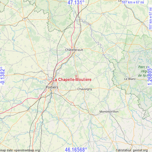
La Chapelle-Moulière GPS coordinates[2]
46° 39' 1.764" North, 0° 33' 53.748" East
| Map corner | latitude | longitude |
|---|---|---|
| Upper-left | 47.131°, | -0.1382° |
| Center: | 46.65049°, | 0.56493° |
| Lower-right: | 46.16568°, | 1.26805° |
| Map W x H: | 107.3×107.3 km | = 66.7×66.7mi |
| max Lat: | 51.07786° ⇑58.7% North |
| La Chapelle-Moulière: | 46.65049° |
| min Lat: | ⇓41.3% South 41.3874° |
| min Long | La Chapelle-Mou | max Long |
| -5.08615° | 0.56493° | 9.52242° |
| W 27.3%⇐ | ⇒72.7% E |
Elevation
Elevation of La Chapelle-Moulière is 96 m = 315 ft, and this is 97.7 m = 321 ft below average elevation for this country.
| Max E: |
2333 m = 7654 ft | 62.4% |
| Avg. | 193.7 m = 635 ft | |
| La Chapelle-Moulière | 96 m = 315 ft | |
Min E: |
-1 m = -3 ft | 37.6% |
See also: France elevation on elevation.city.
Geographical zone
La Chapelle-Moulière is located in North temperate zone (between Tropic of Cancer and the Arctic Circle). Distance of this North polar circle is 2214.1 km =1375.8 mi to North.| Distance of | km | miles | from La Chapelle-Moulière |
|---|---|---|---|
| North Pole | 4820 | 2995 | to North |
| Arctic Circle | 2214.1 | 1375.8 | to North |
| Tropic Cancer | 2581.1 | 1603.8 | to South |
| Equator | 5187 | 3223.1 | to South |


Nearby cities:
15 places around La Chapelle-Moulière: (largest is in red/bold)
• Archigny
7.1 km =4.4 mi,  69°
69°
• Bignoux
9.2 km =5.7 mi,  232°
232°
• Bonnes
5.6 km =3.5 mi,  155°
155°
• Bonneuil-Matours
3.5 km =2.2 mi,  5°
5°
• Buxerolles
7.3 km =4.5 mi,  238°
238°
• Chauvigny
10.8 km =6.7 mi,  146°
146°
• Dissay
11.6 km =7.2 mi,  298°
298°
• Jardres
9.1 km =5.7 mi,  180°
180°
• Lavoux
6.6 km =4.1 mi,  204°
204°
• Liniers
4.9 km =3 mi,  205°
205°
• Montamisé
11.2 km =7 mi,  253°
253°
• Monthoiron
10.1 km =6.3 mi,  24°
24°
• Saint-Cyr
12.1 km =7.5 mi,  308°
308°
• Sèvres-Anxaumont
11.8 km =7.3 mi,  220°
220°
• Vouneuil-sur-Vienne
7.7 km =4.8 mi,  345°
345°
Sources, notices
• [Note1] Compared only with cities in France existing in our database
• [Src1] Map data: © OpenStreetMap contributors (CC-BY-SA)
• [Src2] Other city data from geonames.org with taken over terms of usage.
• [Src3] Geographical zone / Annual Mean Temperature by Robert A. Rohde @ Wikipedia
